|
|
|||||||||||||||||
| Point ID: 3090 | Downloads | Plots | Site Data | Code: 05SB004 |
|
|
|||||||||||||||||
| Download | |
|---|---|
| Site Descriptor Information | Site Time Series Data |
| Link to all available data | |
| View: | Time Series | All |
| Units: | m3/s |
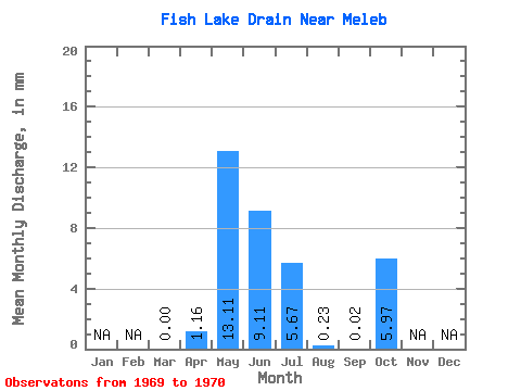
| Statistic | Jan | Feb | Mar | Apr | May | Jun | Jul | Aug | Sep | Oct | Nov | Dec | Annual |
|---|---|---|---|---|---|---|---|---|---|---|---|---|---|
| Mean | 0.00 | 1.16 | 13.12 | 9.12 | 5.66 | 0.23 | 0.01 | 5.97 | |||||
| Standard Deviation | 0.00 | 1.54 | 10.35 | 0.78 | 6.04 | 0.27 | 0.01 | 2.39 | |||||
| Min | 0.00 | 0.07 | 5.80 | 8.56 | 1.39 | 0.04 | 0.00 | 4.28 | |||||
| Max | 0.00 | 2.25 | 20.44 | 9.67 | 9.94 | 0.42 | 0.02 | 7.66 | |||||
| Coefficient of Variation | 1.33 | 0.79 | 0.09 | 1.07 | 1.20 | 1.41 | 0.40 |
 Return to R-Arctic Net Home Page