|
|
| Point ID: 3090 | Downloads | Plots | Site Data | Code: 05SB004 |
|
| Download | |
|---|---|
| Site Descriptor Information | Site Time Series Data |
| Link to all available data | |
|
|
|
| View: | Statistics | All |
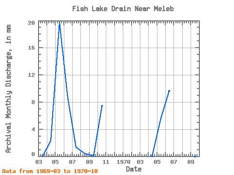
| Units: | m3/s |
| Year | Jan | Feb | Mar | Apr | May | Jun | Jul | Aug | Sep | Oct | Nov | Dec | Annual | 1969 | 0.00 | 2.25 | 20.44 | 8.56 | 1.39 | 0.42 | 0.02 | 7.66 | 1970 | 0.00 | 0.07 | 5.80 | 9.67 | 9.94 | 0.04 | 0.00 | 4.28 |
|---|
 Return to R-Arctic Net Home Page