|
|
|||||||||||||||||
| Point ID: 2935 | Downloads | Plots | Site Data | Code: 05NF014 |
|
|
|||||||||||||||||
| Download | |
|---|---|
| Site Descriptor Information | Site Time Series Data |
| Link to all available data | |
| View: | Time Series | All |
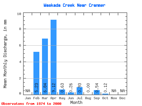
| Units: | m3/s |
| Statistic | Jan | Feb | Mar | Apr | May | Jun | Jul | Aug | Sep | Oct | Nov | Dec | Annual |
|---|---|---|---|---|---|---|---|---|---|---|---|---|---|
| Mean | 5.28 | 6.85 | 9.11 | 0.64 | 0.27 | 0.92 | 0.00 | 0.53 | 0.12 | ||||
| Standard Deviation | 12.20 | 14.38 | 1.79 | 0.61 | 2.46 | 0.01 | 2.38 | 0.38 | |||||
| Min | 5.28 | 0.00 | 0.00 | 0.00 | 0.00 | 0.00 | 0.00 | 0.00 | 0.00 | ||||
| Max | 5.28 | 43.09 | 43.83 | 6.84 | 2.40 | 10.47 | 0.02 | 10.65 | 1.66 | ||||
| Coefficient of Variation | 1.78 | 1.58 | 2.79 | 2.28 | 2.68 | 4.47 | 4.46 | 3.09 |
 Return to R-Arctic Net Home Page