|
|
|||||||||||||||||
| Point ID: 2935 | Downloads | Plots | Site Data | Code: 05NF014 |
|
|
|||||||||||||||||
| Download | |
|---|---|
| Site Descriptor Information | Site Time Series Data |
| Link to all available data | |
|
|
| View: | Statistics | Time Series |
| Units: | m3/s |
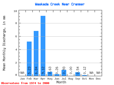
| Statistic | Jan | Feb | Mar | Apr | May | Jun | Jul | Aug | Sep | Oct | Nov | Dec | Annual |
|---|---|---|---|---|---|---|---|---|---|---|---|---|---|
| Mean | 5.28 | 6.85 | 9.11 | 0.64 | 0.27 | 0.92 | 0.00 | 0.53 | 0.12 | ||||
| Standard Deviation | 12.20 | 14.38 | 1.79 | 0.61 | 2.46 | 0.01 | 2.38 | 0.38 | |||||
| Min | 5.28 | 0.00 | 0.00 | 0.00 | 0.00 | 0.00 | 0.00 | 0.00 | 0.00 | ||||
| Max | 5.28 | 43.09 | 43.83 | 6.84 | 2.40 | 10.47 | 0.02 | 10.65 | 1.66 | ||||
| Coefficient of Variation | 1.78 | 1.58 | 2.79 | 2.28 | 2.68 | 4.47 | 4.46 | 3.09 |
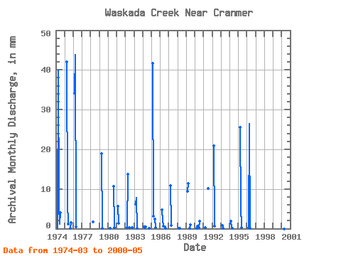
| Year | Jan | Feb | Mar | Apr | May | Jun | Jul | Aug | Sep | Oct | Nov | Dec | Annual | 1974 | 0.00 | 39.82 | 5.99 | 1.13 | 4.14 | 0.00 | 0.00 | 0.00 | 1975 | 0.00 | 41.94 | 6.84 | 1.18 | 0.00 | 0.00 | 0.02 | 1.66 | 1976 | 35.30 | 43.83 | 0.49 | 0.00 | 0.00 | 0.00 | 0.00 | 0.00 | 1977 | 0.00 | 0.00 | 0.00 | 0.00 | 0.00 | 0.00 | 0.00 | 0.00 | 1978 | 0.00 | 1.65 | 0.00 | 0.00 | 0.00 | 0.00 | 0.00 | 0.00 | 1979 | 0.00 | 18.87 | 0.10 | 0.00 | 0.00 | 0.00 | 0.00 | 0.00 | 1980 | 0.00 | 0.02 | 0.00 | 0.00 | 0.00 | 0.00 | 10.65 | 0.36 | 1981 | 5.28 | 1.36 | 0.00 | 0.00 | 0.00 | 0.00 | 0.00 | 0.00 | 0.00 | 1982 | 0.27 | 13.71 | 0.00 | 0.33 | 0.00 | 0.00 | 0.00 | 0.32 | 1983 | 6.43 | 7.87 | 0.05 | 0.00 | 0.00 | 0.00 | 0.00 | 0.00 | 1984 | 0.46 | 0.02 | 0.49 | 0.00 | 0.00 | 0.00 | 0.00 | 0.10 | 1985 | 43.09 | 3.11 | 0.00 | 2.40 | 0.24 | 0.00 | 0.00 | 0.00 | 1986 | 4.99 | 2.10 | 0.66 | 0.00 | 0.44 | 0.02 | 0.00 | 0.00 | 1987 | 11.13 | 0.78 | 0.00 | 0.00 | 0.00 | 0.00 | 0.00 | 0.00 | 1988 | 0.07 | 0.17 | 0.00 | 0.00 | 0.00 | 0.00 | 0.00 | 0.00 | 1989 | 9.76 | 11.43 | 0.00 | 0.07 | 1.07 | 0.00 | 0.00 | 0.00 | 1990 | 0.12 | 0.68 | 0.00 | 0.28 | 2.00 | 0.00 | 0.00 | 0.00 | 1991 | 0.29 | 0.00 | 0.00 | 0.00 | 10.47 | 0.00 | 0.00 | 0.00 | 1992 | 21.55 | 0.54 | 0.00 | 0.00 | 0.00 | 0.00 | 0.00 | 0.00 | 1993 | 0.80 | 0.02 | 0.00 | 0.00 | 0.00 | 0.00 | 0.00 | 0.00 | 1994 | 1.90 | 0.09 | 0.02 | 1995 | 26.29 | 5.58 | 0.22 | 1996 | 0.36 | 26.39 | 0.15 | 2000 | 0.12 | 0.00 | 0.41 |
|---|
 Return to R-Arctic Net Home Page