|
|
|||||||||||||||||
| Point ID: 2758 | Downloads | Plots | Site Data | Other Close Sites | Code: 10BB001 |
|
|
|||||||||||||||||
| Download | |
|---|---|
| Site Descriptor Information | Site Time Series Data |
| Link to all available data | |
| View: | Time Series | All |
| Units: | m3/s |
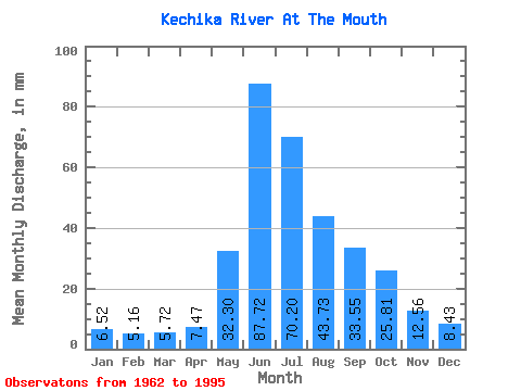
| Statistic | Jan | Feb | Mar | Apr | May | Jun | Jul | Aug | Sep | Oct | Nov | Dec | Annual |
|---|---|---|---|---|---|---|---|---|---|---|---|---|---|
| Mean | 6.52 | 5.21 | 5.72 | 7.47 | 32.30 | 87.72 | 70.19 | 43.72 | 33.55 | 25.80 | 12.56 | 8.43 | 340.27 |
| Standard Deviation | 1.06 | 0.96 | 1.22 | 2.15 | 11.81 | 19.84 | 19.15 | 9.04 | 6.94 | 6.33 | 2.45 | 1.37 | 35.48 |
| Min | 4.73 | 2.98 | 3.13 | 4.32 | 14.39 | 60.29 | 34.45 | 30.32 | 20.44 | 18.05 | 8.97 | 6.55 | 250.32 |
| Max | 8.35 | 7.00 | 9.04 | 14.16 | 67.60 | 142.73 | 107.24 | 68.54 | 45.22 | 43.65 | 19.18 | 12.98 | 389.62 |
| Coefficient of Variation | 0.16 | 0.18 | 0.21 | 0.29 | 0.37 | 0.23 | 0.27 | 0.21 | 0.21 | 0.24 | 0.20 | 0.16 | 0.10 |
| Other Close Sites | ||||||
|---|---|---|---|---|---|---|
| PointID | Latitude | Longitude | Drainage Area | Source | Name | |
| 2765 | "LIARD RIVER ABOVE KECHIKA RIVER" | 59.70 | 2014363 | Hydat | ||
 Return to R-Arctic Net Home Page