|
|
|||||||||||||||||
| Point ID: 267 | Downloads | Plots | Site Data | Code: 05BF018 |
|
|
|||||||||||||||||
| Download | |
|---|---|
| Site Descriptor Information | Site Time Series Data |
| Link to all available data | |
| View: | Time Series | All |
| Units: | m3/s |
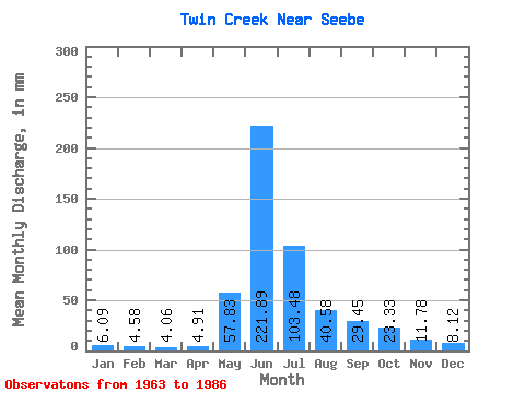
| Statistic | Jan | Feb | Mar | Apr | May | Jun | Jul | Aug | Sep | Oct | Nov | Dec | Annual |
|---|---|---|---|---|---|---|---|---|---|---|---|---|---|
| Mean | 5.95 | 4.29 | 3.86 | 5.00 | 58.09 | 222.14 | 102.96 | 41.04 | 29.62 | 22.87 | 12.23 | 8.41 | 514.52 |
| Standard Deviation | 1.69 | 1.41 | 1.56 | 2.60 | 36.34 | 61.55 | 36.68 | 15.75 | 16.69 | 11.67 | 4.83 | 2.63 | 100.50 |
| Min | 4.06 | 0.92 | 1.01 | 0.98 | 13.19 | 109.96 | 36.52 | 21.30 | 13.74 | 10.14 | 6.87 | 4.06 | 332.74 |
| Max | 10.14 | 7.39 | 6.09 | 10.80 | 137.96 | 333.82 | 170.42 | 81.15 | 84.44 | 55.79 | 26.51 | 14.20 | 681.41 |
| Coefficient of Variation | 0.28 | 0.33 | 0.40 | 0.52 | 0.63 | 0.28 | 0.36 | 0.38 | 0.56 | 0.51 | 0.40 | 0.31 | 0.20 |
 Return to R-Arctic Net Home Page