|
|
|||||||||||||||||
| Point ID: 267 | Downloads | Plots | Site Data | Code: 05BF018 |
|
|
|||||||||||||||||
| Download | |
|---|---|
| Site Descriptor Information | Site Time Series Data |
| Link to all available data | |
|
|
| View: | Statistics | Time Series |
| Units: | m3/s |
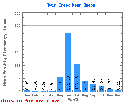
| Statistic | Jan | Feb | Mar | Apr | May | Jun | Jul | Aug | Sep | Oct | Nov | Dec | Annual |
|---|---|---|---|---|---|---|---|---|---|---|---|---|---|
| Mean | 5.95 | 4.29 | 3.86 | 5.00 | 58.09 | 222.14 | 102.96 | 41.04 | 29.62 | 22.87 | 12.23 | 8.41 | 514.52 |
| Standard Deviation | 1.69 | 1.41 | 1.56 | 2.60 | 36.34 | 61.55 | 36.68 | 15.75 | 16.69 | 11.67 | 4.83 | 2.63 | 100.50 |
| Min | 4.06 | 0.92 | 1.01 | 0.98 | 13.19 | 109.96 | 36.52 | 21.30 | 13.74 | 10.14 | 6.87 | 4.06 | 332.74 |
| Max | 10.14 | 7.39 | 6.09 | 10.80 | 137.96 | 333.82 | 170.42 | 81.15 | 84.44 | 55.79 | 26.51 | 14.20 | 681.41 |
| Coefficient of Variation | 0.28 | 0.33 | 0.40 | 0.52 | 0.63 | 0.28 | 0.36 | 0.38 | 0.56 | 0.51 | 0.40 | 0.31 | 0.20 |
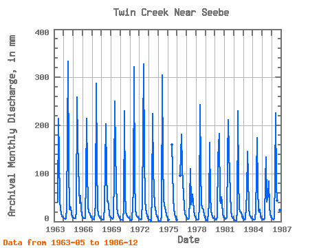
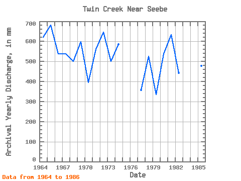
| Year | Jan | Feb | Mar | Apr | May | Jun | Jul | Aug | Sep | Oct | Nov | Dec | Annual | 1963 | 42.60 | 214.04 | 141.00 | 43.62 | 25.53 | 17.25 | 10.80 | 8.12 | 1964 | 6.09 | 5.54 | 5.07 | 6.87 | 28.40 | 333.82 | 119.70 | 25.36 | 30.44 | 30.43 | 14.73 | 10.14 | 618.65 | 1965 | 8.12 | 6.47 | 6.09 | 5.89 | 22.32 | 258.22 | 170.42 | 69.99 | 38.29 | 55.79 | 26.51 | 14.20 | 681.41 | 1966 | 10.14 | 7.39 | 6.09 | 5.89 | 92.31 | 215.02 | 114.63 | 33.48 | 19.64 | 17.25 | 9.82 | 8.12 | 538.95 | 1967 | 6.09 | 4.62 | 5.07 | 3.93 | 36.52 | 287.67 | 125.78 | 29.42 | 14.73 | 11.16 | 7.86 | 6.09 | 539.95 | 1968 | 5.07 | 3.70 | 3.04 | 2.94 | 33.48 | 202.25 | 108.54 | 43.62 | 42.22 | 36.52 | 11.78 | 10.14 | 503.09 | 1969 | 8.12 | 6.47 | 5.07 | 9.82 | 95.35 | 250.36 | 148.10 | 30.43 | 17.67 | 13.19 | 8.84 | 6.09 | 598.72 | 1970 | 4.06 | 3.70 | 3.04 | 1.96 | 28.40 | 229.75 | 62.89 | 21.30 | 13.74 | 10.14 | 7.86 | 6.09 | 394.50 | 1971 | 4.06 | 3.70 | 2.03 | 3.93 | 67.96 | 322.04 | 91.30 | 27.39 | 13.74 | 11.16 | 8.84 | 6.09 | 563.86 | 1972 | 5.07 | 4.62 | 4.06 | 4.91 | 43.62 | 327.93 | 139.99 | 46.66 | 26.51 | 20.29 | 11.78 | 7.10 | 643.55 | 1973 | 4.06 | 2.77 | 1.01 | 0.98 | 56.81 | 224.84 | 109.56 | 31.45 | 29.45 | 17.25 | 10.80 | 9.13 | 498.11 | 1974 | 4.06 | 0.92 | 1.01 | 1.96 | 13.19 | 304.36 | 131.87 | 48.69 | 33.38 | 23.33 | 13.74 | 9.13 | 586.77 | 1975 | 6.09 | 3.70 | 160.04 | 113.61 | 49.70 | 26.51 | 15.22 | 8.84 | 4.06 | 1976 | 98.40 | 181.64 | 117.67 | 81.15 | 58.91 | 29.42 | 16.69 | 12.17 | 1977 | 6.09 | 4.62 | 5.07 | 6.87 | 47.68 | 109.96 | 36.52 | 57.82 | 41.24 | 24.34 | 13.74 | 9.13 | 362.62 | 1978 | 7.10 | 4.62 | 4.06 | 4.91 | 31.45 | 243.49 | 113.61 | 37.53 | 27.49 | 25.36 | 12.76 | 9.13 | 522.01 | 1979 | 5.07 | 3.70 | 2.03 | 1.96 | 36.52 | 163.96 | 55.79 | 23.33 | 15.71 | 10.14 | 6.87 | 7.10 | 332.74 | 1980 | 5.07 | 3.70 | 4.06 | 10.80 | 134.91 | 182.62 | 44.63 | 38.55 | 51.05 | 40.58 | 15.71 | 10.14 | 540.94 | 1981 | 8.12 | 4.62 | 6.09 | 7.86 | 137.96 | 211.09 | 147.09 | 61.88 | 20.62 | 13.19 | 7.86 | 6.09 | 629.61 | 1982 | 4.06 | 2.77 | 2.03 | 1.96 | 23.33 | 229.75 | 89.27 | 28.40 | 20.62 | 19.27 | 10.80 | 7.10 | 440.33 | 1983 | 6.09 | 3.70 | 4.06 | 4.91 | 58.84 | 145.31 | 97.38 | 29.42 | 15.71 | 11.16 | 7.86 | 5.07 | 388.52 | 1984 | 5.07 | 3.70 | 4.06 | 4.91 | 23.33 | 173.78 | 69.99 | 24.34 | 18.66 | 25.36 | 10.80 | 7.10 | 371.59 | 1985 | 5.07 | 3.70 | 4.06 | 5.89 | 89.27 | 133.53 | 42.60 | 55.79 | 84.44 | 32.46 | 14.73 | 10.14 | 481.17 | 1986 | 8.12 | 5.54 | 4.06 | 5.89 | 93.32 | 225.82 | 79.12 | 45.65 | 24.55 | 38.55 | 23.56 | 14.20 | 567.84 |
|---|
 Return to R-Arctic Net Home Page