|
|
|||||||||||||||||
| Point ID: 223 | Downloads | Plots | Site Data | Code: 05BA001 |
|
|
|||||||||||||||||
| Download | |
|---|---|
| Site Descriptor Information | Site Time Series Data |
| Link to all available data | |
| View: | Time Series | All |
| Units: | m3/s |
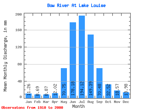
| Statistic | Jan | Feb | Mar | Apr | May | Jun | Jul | Aug | Sep | Oct | Nov | Dec | Annual |
|---|---|---|---|---|---|---|---|---|---|---|---|---|---|
| Mean | 11.26 | 8.77 | 8.87 | 12.02 | 70.74 | 178.18 | 194.10 | 149.36 | 70.47 | 32.52 | 18.57 | 13.98 | 785.50 |
| Standard Deviation | 2.40 | 1.52 | 1.28 | 4.08 | 26.36 | 44.75 | 38.81 | 31.25 | 18.26 | 8.12 | 3.33 | 2.67 | 94.14 |
| Min | 7.89 | 6.38 | 6.68 | 7.33 | 31.17 | 117.59 | 125.31 | 88.42 | 44.21 | 19.34 | 11.57 | 9.22 | 623.83 |
| Max | 17.49 | 14.03 | 12.53 | 25.12 | 157.12 | 307.84 | 312.96 | 222.00 | 125.60 | 59.03 | 26.35 | 20.48 | 1005.71 |
| Coefficient of Variation | 0.21 | 0.17 | 0.14 | 0.34 | 0.37 | 0.25 | 0.20 | 0.21 | 0.26 | 0.25 | 0.18 | 0.19 | 0.12 |
 Return to R-Arctic Net Home Page