|
|
|||||||||||||||||
| Point ID: 223 | Downloads | Plots | Site Data | Code: 05BA001 |
|
|
|||||||||||||||||
| Download | |
|---|---|
| Site Descriptor Information | Site Time Series Data |
| Link to all available data | |
|
|
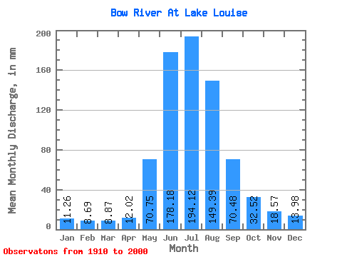
| View: | Statistics | Time Series |
| Units: | m3/s |
| Statistic | Jan | Feb | Mar | Apr | May | Jun | Jul | Aug | Sep | Oct | Nov | Dec | Annual |
|---|---|---|---|---|---|---|---|---|---|---|---|---|---|
| Mean | 11.26 | 8.77 | 8.87 | 12.02 | 70.74 | 178.18 | 194.10 | 149.36 | 70.47 | 32.52 | 18.57 | 13.98 | 785.50 |
| Standard Deviation | 2.40 | 1.52 | 1.28 | 4.08 | 26.36 | 44.75 | 38.81 | 31.25 | 18.26 | 8.12 | 3.33 | 2.67 | 94.14 |
| Min | 7.89 | 6.38 | 6.68 | 7.33 | 31.17 | 117.59 | 125.31 | 88.42 | 44.21 | 19.34 | 11.57 | 9.22 | 623.83 |
| Max | 17.49 | 14.03 | 12.53 | 25.12 | 157.12 | 307.84 | 312.96 | 222.00 | 125.60 | 59.03 | 26.35 | 20.48 | 1005.71 |
| Coefficient of Variation | 0.21 | 0.17 | 0.14 | 0.34 | 0.37 | 0.25 | 0.20 | 0.21 | 0.26 | 0.25 | 0.18 | 0.19 | 0.12 |
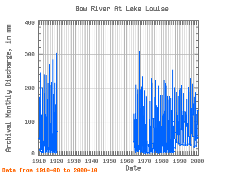
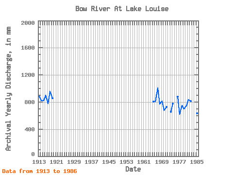
| Year | Jan | Feb | Mar | Apr | May | Jun | Jul | Aug | Sep | Oct | Nov | Dec | Annual | 1910 | 178.75 | 49.50 | 1911 | 17.49 | 9.51 | 10.50 | 17.30 | 57.19 | 244.42 | 236.00 | 161.57 | 84.35 | 19.34 | 1912 | 10.32 | 7.51 | 9.61 | 58.52 | 176.70 | 180.65 | 206.73 | 61.26 | 26.08 | 16.62 | 13.61 | 1913 | 7.89 | 6.84 | 7.82 | 14.10 | 69.97 | 238.27 | 196.56 | 181.29 | 97.28 | 35.81 | 17.55 | 13.87 | 883.96 | 1914 | 11.20 | 8.52 | 9.86 | 10.28 | 67.43 | 176.70 | 244.90 | 163.48 | 70.80 | 34.99 | 17.24 | 10.88 | 821.24 | 1915 | 9.03 | 7.48 | 8.08 | 25.12 | 66.79 | 139.14 | 199.74 | 220.09 | 84.35 | 29.13 | 18.47 | 16.73 | 818.80 | 1916 | 11.45 | 8.69 | 12.53 | 10.71 | 39.18 | 244.42 | 277.98 | 150.12 | 86.19 | 33.27 | 19.21 | 12.79 | 902.88 | 1917 | 10.50 | 8.69 | 8.14 | 7.33 | 68.70 | 124.98 | 222.64 | 160.30 | 75.73 | 55.47 | 20.81 | 17.30 | 774.88 | 1918 | 12.79 | 8.81 | 9.61 | 11.08 | 71.88 | 283.83 | 214.37 | 160.93 | 105.90 | 50.83 | 16.62 | 15.33 | 959.17 | 1919 | 10.05 | 8.00 | 9.92 | 13.24 | 93.51 | 163.15 | 204.83 | 222.00 | 85.58 | 27.86 | 14.59 | 11.01 | 858.03 | 1920 | 9.80 | 8.23 | 7.38 | 9.67 | 40.01 | 118.21 | 312.96 | 186.38 | 70.80 | 1964 | 41.79 | 117.59 | 126.58 | 92.23 | 55.29 | 47.90 | 26.35 | 19.15 | 1965 | 16.35 | 14.03 | 10.30 | 18.10 | 59.48 | 189.63 | 215.64 | 175.56 | 45.81 | 32.82 | 20.01 | 14.57 | 807.99 | 1966 | 13.36 | 9.51 | 10.37 | 11.70 | 98.60 | 168.69 | 200.37 | 137.40 | 80.04 | 33.90 | 24.81 | 20.48 | 804.93 | 1967 | 13.80 | 10.43 | 11.07 | 10.28 | 49.74 | 307.84 | 253.81 | 170.48 | 110.82 | 35.49 | 20.26 | 14.12 | 1005.71 | 1968 | 15.27 | 11.24 | 9.67 | 8.13 | 56.17 | 185.93 | 209.91 | 136.76 | 72.03 | 33.20 | 20.93 | 14.63 | 770.45 | 1969 | 9.16 | 8.46 | 8.78 | 21.12 | 110.05 | 233.34 | 163.48 | 136.76 | 59.78 | 32.06 | 21.86 | 13.93 | 815.86 | 1970 | 9.67 | 6.78 | 6.87 | 7.88 | 44.97 | 190.86 | 183.20 | 143.12 | 44.21 | 19.91 | 11.64 | 9.22 | 675.12 | 1971 | 8.90 | 7.25 | 6.68 | 10.34 | 75.70 | 175.47 | 155.85 | 178.75 | 58.86 | 26.21 | 15.64 | 10.24 | 725.97 | 1972 | 10.69 | 7.82 | 9.41 | 8.00 | 32.00 | 20.56 | 15.52 | 1973 | 14.95 | 9.33 | 7.06 | 9.17 | 71.24 | 144.07 | 164.75 | 123.40 | 54.73 | 29.83 | 19.70 | 13.80 | 658.50 | 1974 | 8.14 | 9.91 | 8.78 | 11.27 | 43.70 | 226.57 | 209.91 | 143.12 | 66.49 | 26.46 | 16.07 | 11.64 | 779.44 | 1975 | 9.29 | 7.30 | 8.14 | 8.37 | 36.19 | 111.32 | 53.81 | 29.01 | 23.95 | 13.74 | 1976 | 10.69 | 10.32 | 8.90 | 11.02 | 106.87 | 119.44 | 229.63 | 187.01 | 125.60 | 39.88 | 17.73 | 14.57 | 875.77 | 1977 | 10.43 | 7.77 | 10.05 | 13.24 | 58.65 | 146.53 | 125.31 | 146.30 | 54.36 | 23.47 | 16.38 | 14.31 | 623.83 | 1978 | 9.73 | 6.38 | 8.71 | 12.25 | 52.22 | 175.47 | 212.46 | 120.86 | 83.12 | 35.37 | 18.22 | 15.20 | 746.58 | 1979 | 9.10 | 8.98 | 8.52 | 9.11 | 52.22 | 158.23 | 182.56 | 146.94 | 71.42 | 31.68 | 11.57 | 12.91 | 699.67 | 1980 | 10.88 | 7.77 | 8.21 | 18.66 | 157.12 | 177.93 | 153.94 | 88.42 | 50.61 | 36.19 | 17.73 | 18.57 | 742.02 | 1981 | 13.48 | 8.00 | 8.33 | 12.68 | 121.50 | 127.44 | 230.91 | 190.83 | 78.19 | 24.30 | 15.88 | 12.72 | 837.54 | 1982 | 10.88 | 9.97 | 8.78 | 8.19 | 46.24 | 212.41 | 204.83 | 140.58 | 104.67 | 36.89 | 20.32 | 16.09 | 817.36 | 1983 | 12.53 | 8.81 | 8.46 | 10.28 | 64.25 | 153.92 | 181.29 | 159.03 | 53.62 | 23.54 | 21.80 | 11.20 | 704.66 | 1984 | 11.39 | 8.06 | 7.95 | 12.13 | 31.17 | 155.77 | 180.02 | 162.21 | 68.34 | 30.15 | 18.72 | 13.55 | 695.98 | 1985 | 9.54 | 9.62 | 8.52 | 13.36 | 90.33 | 127.44 | 173.66 | 100.50 | 50.73 | 27.99 | 15.88 | 9.99 | 633.82 | 1986 | 10.56 | 7.82 | 8.97 | 10.96 | 87.15 | 253.66 | 156.48 | 120.86 | 57.01 | 26.72 | 18.47 | 11.70 | 768.38 | 1987 | 103.05 | 153.30 | 207.37 | 94.78 | 74.50 | 23.41 | 1988 | 70.61 | 187.17 | 140.58 | 121.50 | 67.72 | 40.01 | 1989 | 64.88 | 173.62 | 165.39 | 145.67 | 58.80 | 35.88 | 1990 | 64.88 | 188.40 | 205.46 | 144.40 | 67.72 | 32.51 | 1991 | 80.78 | 170.54 | 213.73 | 173.66 | 68.96 | 32.76 | 1992 | 78.88 | 183.47 | 144.40 | 112.59 | 46.67 | 32.12 | 1993 | 102.41 | 129.29 | 125.31 | 132.31 | 60.89 | 32.57 | 1994 | 91.60 | 151.46 | 171.11 | 127.86 | 64.03 | 31.17 | 1995 | 63.10 | 201.33 | 180.02 | 141.22 | 78.81 | 34.54 | 1996 | 52.80 | 195.17 | 234.72 | 128.49 | 56.77 | 31.87 | 1997 | 66.79 | 211.79 | 167.93 | 141.85 | 89.27 | 59.03 | 1998 | 124.68 | 134.22 | 178.11 | 144.40 | 83.73 | 25.32 | 1999 | 48.53 | 147.76 | 192.10 | 178.75 | 70.19 | 29.45 | 2000 | 52.61 | 132.37 | 202.92 | 128.49 | 53.01 | 27.35 |
|---|
 Return to R-Arctic Net Home Page