|
|
| Point ID: 5808 | Downloads | Plots | Site Data | Code: 09BC003 |
|
| Download | |
|---|---|
| Site Descriptor Information | Site Time Series Data |
| Link to all available data | |
|
|
|
| View: | Statistics | All |
| Units: | m3/s |
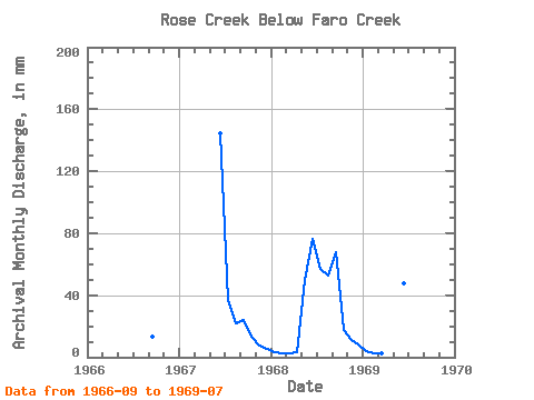
| Year | Jan | Feb | Mar | Apr | May | Jun | Jul | Aug | Sep | Oct | Nov | Dec | Annual | 1966 | 13.09 | 1967 | 144.55 | 38.50 | 22.92 | 23.80 | 13.52 | 7.53 | 5.51 | 1968 | 3.53 | 2.43 | 2.59 | 2.93 | 51.63 | 76.51 | 58.97 | 54.59 | 67.67 | 17.90 | 11.43 | 8.25 | 357.39 | 1969 | 3.81 | 2.52 | 2.70 | 3.14 | 33.09 | 47.35 | 32.83 |
|---|
 Return to R-Arctic Net Home Page