|
|
|||||||||||||||||
| Point ID: 5808 | Downloads | Plots | Site Data | Code: 09BC003 |
|
|
|||||||||||||||||
| Download | |
|---|---|
| Site Descriptor Information | Site Time Series Data |
| Link to all available data | |
|
|
| View: | Statistics | Time Series |
| Units: | m3/s |
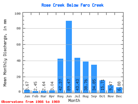
| Statistic | Jan | Feb | Mar | Apr | May | Jun | Jul | Aug | Sep | Oct | Nov | Dec | Annual |
|---|---|---|---|---|---|---|---|---|---|---|---|---|---|
| Mean | 3.67 | 2.48 | 2.65 | 3.03 | 42.36 | 89.47 | 43.43 | 38.75 | 34.85 | 15.71 | 9.48 | 6.88 | 357.39 |
| Standard Deviation | 0.20 | 0.07 | 0.08 | 0.15 | 13.11 | 49.88 | 13.75 | 22.40 | 28.92 | 3.10 | 2.76 | 1.94 | |
| Min | 3.53 | 2.43 | 2.59 | 2.93 | 33.09 | 47.35 | 32.83 | 22.92 | 13.09 | 13.52 | 7.53 | 5.51 | 357.39 |
| Max | 3.81 | 2.52 | 2.70 | 3.14 | 51.63 | 144.55 | 58.97 | 54.59 | 67.67 | 17.90 | 11.43 | 8.25 | 357.39 |
| Coefficient of Variation | 0.06 | 0.03 | 0.03 | 0.05 | 0.31 | 0.56 | 0.32 | 0.58 | 0.83 | 0.20 | 0.29 | 0.28 |
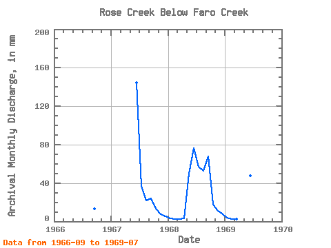
| Year | Jan | Feb | Mar | Apr | May | Jun | Jul | Aug | Sep | Oct | Nov | Dec | Annual | 1966 | 13.09 | 1967 | 144.55 | 38.50 | 22.92 | 23.80 | 13.52 | 7.53 | 5.51 | 1968 | 3.53 | 2.43 | 2.59 | 2.93 | 51.63 | 76.51 | 58.97 | 54.59 | 67.67 | 17.90 | 11.43 | 8.25 | 357.39 | 1969 | 3.81 | 2.52 | 2.70 | 3.14 | 33.09 | 47.35 | 32.83 |
|---|
 Return to R-Arctic Net Home Page