|
|
|||||||||||||||||
| Point ID: 6471 | Downloads | Plots | Site Data | Code: 8172 |
|
|
|||||||||||||||||
| Download | |
|---|---|
| Site Descriptor Information | Site Time Series Data |
| Link to all available data | |
|
|
| View: | Statistics | Time Series |
| Units: | mm |
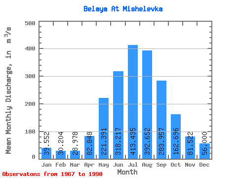
| Statistic | Jan | Feb | Mar | Apr | May | Jun | Jul | Aug | Sep | Oct | Nov | Dec | Annual |
|---|---|---|---|---|---|---|---|---|---|---|---|---|---|
| Mean | 39.55 | 30.20 | 28.98 | 82.85 | 221.39 | 318.22 | 413.44 | 392.65 | 283.96 | 162.70 | 81.52 | 56.00 | 175.95 |
| Standard Deviation | 7.44 | 6.99 | 6.06 | 22.49 | 57.05 | 82.47 | 108.82 | 95.97 | 70.51 | 22.85 | 15.97 | 9.11 | 22.46 |
| Min | 21.70 | 13.90 | 15.90 | 44.50 | 122.00 | 185.00 | 252.00 | 226.00 | 175.00 | 111.00 | 53.30 | 41.00 | 132.29 |
| Max | 53.50 | 45.80 | 39.80 | 121.00 | 379.00 | 505.00 | 695.00 | 623.00 | 445.00 | 203.00 | 117.00 | 75.40 | 227.27 |
| Coefficient of Variation | 0.19 | 0.23 | 0.21 | 0.27 | 0.26 | 0.26 | 0.26 | 0.24 | 0.25 | 0.14 | 0.20 | 0.16 | 0.13 |
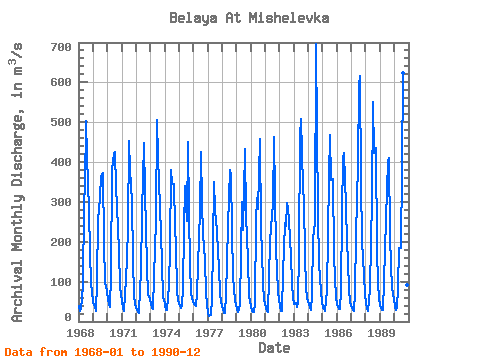
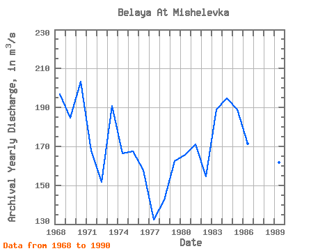
| Year | Jan | Feb | Mar | Apr | May | Jun | Jul | Aug | Sep | Oct | Nov | Dec | Annual | 1967 | 1968 | 39.70 | 26.70 | 32.00 | 89.20 | 297.00 | 338.00 | 504.00 | 414.00 | 279.00 | 172.00 | 95.50 | 74.70 | 196.82 | 1969 | 50.00 | 35.20 | 25.50 | 96.80 | 262.00 | 274.00 | 360.00 | 371.00 | 372.00 | 196.00 | 97.80 | 75.40 | 184.64 | 1970 | 53.50 | 43.50 | 37.60 | 118.00 | 379.00 | 423.00 | 426.00 | 337.00 | 291.00 | 177.00 | 88.40 | 67.60 | 203.47 | 1971 | 50.70 | 30.90 | 27.00 | 109.00 | 155.00 | 240.00 | 454.00 | 380.00 | 303.00 | 154.00 | 65.10 | 46.40 | 167.93 | 1972 | 33.40 | 24.30 | 21.30 | 81.30 | 122.00 | 274.00 | 448.00 | 326.00 | 232.00 | 137.00 | 65.60 | 56.10 | 151.75 | 1973 | 45.10 | 34.40 | 30.90 | 111.00 | 254.00 | 505.00 | 412.00 | 350.00 | 287.00 | 146.00 | 59.70 | 56.00 | 190.93 | 1974 | 42.00 | 28.30 | 28.80 | 88.50 | 184.00 | 380.00 | 346.00 | 345.00 | 237.00 | 186.00 | 76.10 | 53.90 | 166.30 | 1975 | 39.80 | 33.50 | 39.80 | 84.50 | 233.00 | 341.00 | 252.00 | 451.00 | 269.00 | 147.00 | 69.70 | 49.40 | 167.47 | 1976 | 42.80 | 40.50 | 39.20 | 72.30 | 210.00 | 277.00 | 425.00 | 297.00 | 219.00 | 154.00 | 72.20 | 44.60 | 157.80 | 1977 | 21.70 | 13.90 | 15.90 | 56.40 | 192.00 | 349.00 | 281.00 | 226.00 | 175.00 | 135.00 | 72.00 | 49.60 | 132.29 | 1978 | 30.60 | 22.20 | 21.10 | 65.30 | 149.00 | 242.00 | 380.00 | 365.00 | 229.00 | 111.00 | 53.30 | 41.00 | 142.46 | 1979 | 30.80 | 24.50 | 29.30 | 44.50 | 300.00 | 229.00 | 324.00 | 432.00 | 264.00 | 155.00 | 63.60 | 52.00 | 162.39 | 1980 | 36.70 | 25.10 | 23.10 | 47.40 | 251.00 | 309.00 | 282.00 | 458.00 | 232.00 | 175.00 | 93.50 | 54.90 | 165.64 | 1981 | 33.30 | 26.40 | 24.70 | 109.00 | 201.00 | 268.00 | 292.00 | 464.00 | 321.00 | 183.00 | 75.90 | 53.50 | 170.98 | 1982 | 38.70 | 25.60 | 26.80 | 121.00 | 248.00 | 240.00 | 297.00 | 285.00 | 253.00 | 163.00 | 96.00 | 59.20 | 154.44 | 1983 | 44.00 | 45.80 | 37.50 | 46.60 | 179.00 | 462.00 | 508.00 | 337.00 | 300.00 | 164.00 | 82.80 | 59.60 | 188.86 | 1984 | 45.10 | 33.60 | 30.10 | 65.30 | 207.00 | 248.00 | 695.00 | 476.00 | 269.00 | 146.00 | 74.40 | 48.70 | 194.85 | 1985 | 33.00 | 30.50 | 26.10 | 78.00 | 218.00 | 363.00 | 468.00 | 355.00 | 357.00 | 169.00 | 106.00 | 63.70 | 188.94 | 1986 | 40.80 | 31.60 | 32.40 | 78.90 | 271.00 | 411.00 | 424.00 | 291.00 | 197.00 | 151.00 | 78.90 | 49.00 | 171.38 | 1987 | 34.30 | 29.50 | 27.40 | 72.10 | 217.00 | 396.00 | 594.00 | 617.00 | 351.00 | 203.00 | 117.00 | 68.90 | 227.27 | 1988 | 46.50 | 31.30 | 25.90 | 82.30 | 199.00 | 308.00 | 550.00 | 422.00 | 435.00 | 180.00 | 97.20 | 58.40 | 202.97 | 1989 | 40.60 | 28.40 | 29.90 | 102.00 | 180.00 | 257.00 | 402.00 | 409.00 | 214.00 | 140.00 | 83.50 | 56.30 | 161.89 | 1990 | 36.60 | 29.00 | 34.20 | 86.10 | 184.00 | 185.00 | 385.00 | 623.00 | 445.00 | 198.00 | 90.80 | 49.10 | 195.48 |
|---|
 Return to R-Arctic Net Home Page