|
|
|||||||||||||||||
| Point ID: 9667 | Downloads | Plots | Site Data | Code: 05051600 |
|
|
|||||||||||||||||
| Download | |
|---|---|
| Site Descriptor Information | Site Time Series Data |
| Link to all available data | |
| View: | Time Series | All |
| Units: | m3/s |
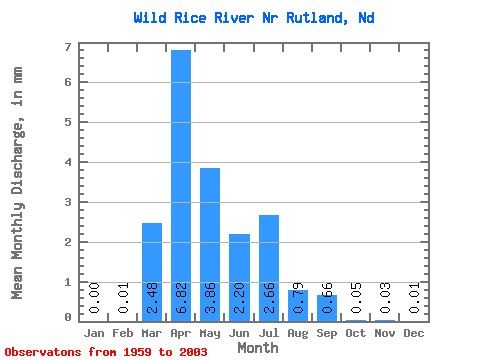
| Statistic | Jan | Feb | Mar | Apr | May | Jun | Jul | Aug | Sep | Oct | Nov | Dec | Annual |
|---|---|---|---|---|---|---|---|---|---|---|---|---|---|
| Mean | 0.00 | 0.00 | 1.35 | 3.70 | 2.09 | 1.20 | 1.44 | 0.43 | 0.36 | 0.03 | 0.02 | 0.01 | 5.53 |
| Standard Deviation | 0.00 | 0.01 | 2.02 | 6.92 | 3.96 | 2.29 | 3.24 | 0.98 | 1.23 | 0.06 | 0.06 | 0.03 | 6.56 |
| Min | 0.00 | 0.00 | 0.00 | 0.00 | 0.00 | 0.00 | 0.00 | 0.00 | 0.00 | 0.00 | 0.00 | 0.00 | 0.00 |
| Max | 0.01 | 0.05 | 7.40 | 39.22 | 22.48 | 13.67 | 20.33 | 5.66 | 7.58 | 0.26 | 0.30 | 0.15 | 28.61 |
| Coefficient of Variation | 4.90 | 3.41 | 1.50 | 1.87 | 1.90 | 1.91 | 2.25 | 2.29 | 3.40 | 2.19 | 3.45 | 4.19 | 1.19 |
 Return to R-Arctic Net Home Page