|
|
|||||||||||||||||
| Point ID: 9667 | Downloads | Plots | Site Data | Code: 05051600 |
|
|
|||||||||||||||||
| Download | |
|---|---|
| Site Descriptor Information | Site Time Series Data |
| Link to all available data | |
| View: | Time Series | All |
| Units: | mm |
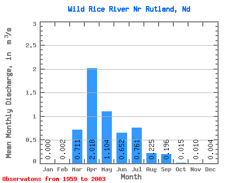
| Statistic | Jan | Feb | Mar | Apr | May | Jun | Jul | Aug | Sep | Oct | Nov | Dec | Annual |
|---|---|---|---|---|---|---|---|---|---|---|---|---|---|
| Mean | 0.00 | 0.00 | 0.71 | 2.02 | 1.10 | 0.65 | 0.76 | 0.23 | 0.20 | 0.01 | 0.01 | 0.00 | 0.25 |
| Standard Deviation | 0.00 | 0.01 | 1.06 | 3.77 | 2.09 | 1.25 | 1.71 | 0.52 | 0.67 | 0.03 | 0.04 | 0.02 | 0.29 |
| Min | 0.00 | 0.00 | 0.00 | 0.00 | 0.00 | 0.00 | 0.00 | 0.00 | 0.00 | 0.00 | 0.00 | 0.00 | 0.00 |
| Max | 0.00 | 0.03 | 3.91 | 21.40 | 11.87 | 7.46 | 10.73 | 2.99 | 4.14 | 0.14 | 0.17 | 0.08 | 1.28 |
| Coefficient of Variation | 4.90 | 3.41 | 1.50 | 1.87 | 1.90 | 1.91 | 2.25 | 2.29 | 3.40 | 2.19 | 3.45 | 4.19 | 1.19 |
 Return to R-Arctic Net Home Page