|
|
|||||||||||||||||
| Point ID: 9593 | Downloads | Plots | Site Data | Code: 05056060 |
|
|
|||||||||||||||||
| Download | |
|---|---|
| Site Descriptor Information | Site Time Series Data |
| Link to all available data | |
| View: | Time Series | All |
| Units: | m3/s |
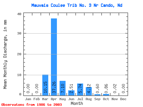
| Statistic | Jan | Feb | Mar | Apr | May | Jun | Jul | Aug | Sep | Oct | Nov | Dec | Annual |
|---|---|---|---|---|---|---|---|---|---|---|---|---|---|
| Mean | 0.00 | 0.00 | 10.14 | 37.26 | 7.09 | 2.50 | 5.73 | 4.13 | 0.60 | 0.85 | 0.01 | 0.00 | |
| Standard Deviation | 18.79 | 44.38 | 12.22 | 4.62 | 11.86 | 9.03 | 1.61 | ||||||
| Min | 0.00 | 0.00 | 0.00 | 0.00 | 0.00 | 0.00 | 0.00 | 0.00 | 0.00 | 0.85 | 0.01 | 0.00 | |
| Max | 0.00 | 0.00 | 68.51 | 118.81 | 45.99 | 18.85 | 45.52 | 29.04 | 6.53 | 0.85 | 0.01 | 0.00 | |
| Coefficient of Variation | 1.85 | 1.19 | 1.72 | 1.84 | 2.07 | 2.19 | 2.67 |
 Return to R-Arctic Net Home Page