|
|
|||||||||||||||||
| Point ID: 9593 | Downloads | Plots | Site Data | Code: 05056060 |
|
|
|||||||||||||||||
| Download | |
|---|---|
| Site Descriptor Information | Site Time Series Data |
| Link to all available data | |
| View: | Time Series | All |
| Units: | mm |
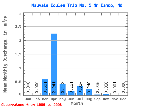
| Statistic | Jan | Feb | Mar | Apr | May | Jun | Jul | Aug | Sep | Oct | Nov | Dec | Annual |
|---|---|---|---|---|---|---|---|---|---|---|---|---|---|
| Mean | 0.00 | 0.00 | 0.59 | 2.24 | 0.41 | 0.15 | 0.33 | 0.24 | 0.04 | 0.05 | 0.00 | 0.00 | |
| Standard Deviation | 1.09 | 2.67 | 0.71 | 0.28 | 0.69 | 0.53 | 0.10 | ||||||
| Min | 0.00 | 0.00 | 0.00 | 0.00 | 0.00 | 0.00 | 0.00 | 0.00 | 0.00 | 0.05 | 0.00 | 0.00 | |
| Max | 0.00 | 0.00 | 3.99 | 7.15 | 2.68 | 1.13 | 2.65 | 1.69 | 0.39 | 0.05 | 0.00 | 0.00 | |
| Coefficient of Variation | 1.85 | 1.19 | 1.72 | 1.84 | 2.07 | 2.19 | 2.67 |
 Return to R-Arctic Net Home Page