|
|
|||||||||||||||||
| Point ID: 9560 | Downloads | Plots | Site Data | Code: 05113700 |
|
|
|||||||||||||||||
| Download | |
|---|---|
| Site Descriptor Information | Site Time Series Data |
| Link to all available data | |
|
|
| View: | Statistics | Time Series |
| Units: | mm |
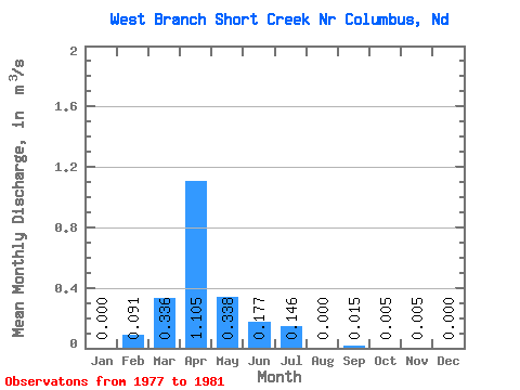
| Statistic | Jan | Feb | Mar | Apr | May | Jun | Jul | Aug | Sep | Oct | Nov | Dec | Annual |
|---|---|---|---|---|---|---|---|---|---|---|---|---|---|
| Mean | 0.00 | 0.09 | 0.34 | 1.10 | 0.34 | 0.18 | 0.15 | 0.00 | 0.01 | 0.01 | 0.01 | 0.00 | 0.23 |
| Standard Deviation | 0.00 | 0.18 | 0.54 | 1.87 | 0.53 | 0.33 | 0.29 | 0.00 | 0.03 | 0.01 | 0.01 | 0.00 | 0.19 |
| Min | 0.00 | 0.00 | 0.01 | 0.00 | 0.00 | 0.00 | 0.00 | 0.00 | 0.00 | 0.00 | 0.00 | 0.00 | 0.04 |
| Max | 0.00 | 0.36 | 1.14 | 3.90 | 1.11 | 0.67 | 0.58 | 0.00 | 0.07 | 0.02 | 0.01 | 0.00 | 0.42 |
| Coefficient of Variation | 2.00 | 1.60 | 1.69 | 1.56 | 1.86 | 2.00 | 2.00 | 2.24 | 2.00 | 1.60 | 2.00 | 0.83 |
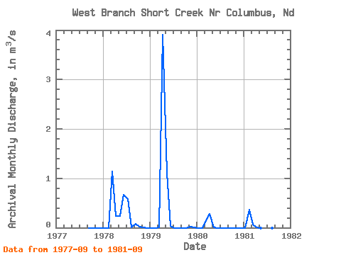
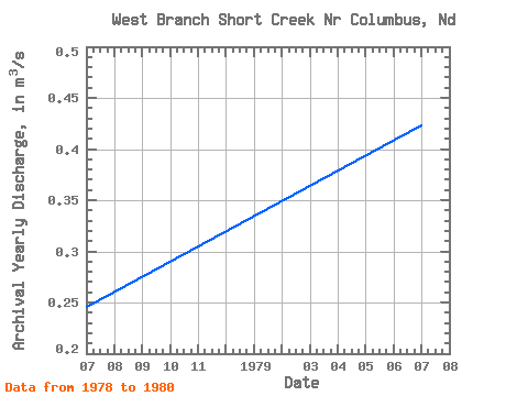
| Year | Jan | Feb | Mar | Apr | May | Jun | Jul | Aug | Sep | Oct | Nov | Dec | Annual | 1977 | 0.00 | 0.00 | 0.00 | 0.00 | 1978 | 0.00 | 0.00 | 1.14 | 0.23 | 0.24 | 0.67 | 0.58 | 0.00 | 0.07 | 0.02 | 0.00 | 0.00 | 0.25 | 1979 | 0.00 | 0.00 | 0.01 | 3.90 | 1.11 | 0.04 | 0.00 | 0.00 | 0.00 | 0.00 | 0.01 | 0.00 | 0.42 | 1980 | 0.00 | 0.00 | 0.13 | 0.28 | 0.01 | 0.00 | 0.00 | 0.00 | 0.00 | 0.00 | 0.00 | 0.00 | 0.04 | 1981 | 0.00 | 0.36 | 0.06 | 0.00 | 0.00 | 0.00 | 0.00 | 0.00 | 0.00 |
|---|
 Return to R-Arctic Net Home Page