|
|
|||||||||||||||||
| Point ID: 9560 | Downloads | Plots | Site Data | Code: 05113700 |
|
|
|||||||||||||||||
| Download | |
|---|---|
| Site Descriptor Information | Site Time Series Data |
| Link to all available data | |
|
|
| View: | Statistics | Time Series |
| Units: | m3/s |
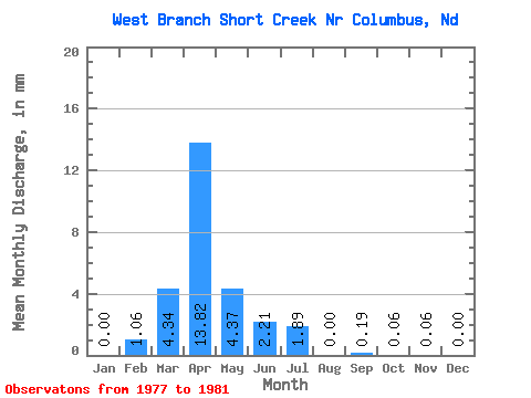
| Statistic | Jan | Feb | Mar | Apr | May | Jun | Jul | Aug | Sep | Oct | Nov | Dec | Annual |
|---|---|---|---|---|---|---|---|---|---|---|---|---|---|
| Mean | 0.00 | 0.51 | 2.08 | 6.62 | 2.09 | 1.06 | 0.90 | 0.00 | 0.09 | 0.03 | 0.03 | 0.00 | 17.14 |
| Standard Deviation | 0.00 | 1.03 | 3.32 | 11.19 | 3.26 | 1.97 | 1.81 | 0.00 | 0.20 | 0.07 | 0.04 | 0.00 | 14.16 |
| Min | 0.00 | 0.00 | 0.07 | 0.02 | 0.00 | 0.00 | 0.00 | 0.00 | 0.00 | 0.00 | 0.00 | 0.00 | 2.58 |
| Max | 0.00 | 2.05 | 7.04 | 23.37 | 6.87 | 4.01 | 3.61 | 0.00 | 0.45 | 0.13 | 0.09 | 0.01 | 30.86 |
| Coefficient of Variation | 2.00 | 1.60 | 1.69 | 1.56 | 1.86 | 2.00 | 2.00 | 2.24 | 2.00 | 1.60 | 2.00 | 0.83 |
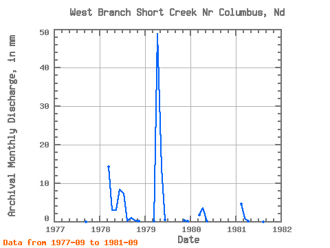
| Year | Jan | Feb | Mar | Apr | May | Jun | Jul | Aug | Sep | Oct | Nov | Dec | Annual | 1977 | 0.00 | 0.00 | 0.00 | 0.00 | 1978 | 0.00 | 0.00 | 7.04 | 1.40 | 1.46 | 4.01 | 3.61 | 0.00 | 0.45 | 0.13 | 0.02 | 0.00 | 17.98 | 1979 | 0.00 | 0.00 | 0.07 | 23.37 | 6.87 | 0.23 | 0.00 | 0.00 | 0.00 | 0.00 | 0.09 | 0.01 | 30.86 | 1980 | 0.00 | 0.00 | 0.83 | 1.71 | 0.03 | 0.00 | 0.00 | 0.00 | 0.00 | 0.00 | 0.00 | 0.00 | 2.58 | 1981 | 0.00 | 2.05 | 0.38 | 0.02 | 0.00 | 0.00 | 0.00 | 0.00 | 0.00 |
|---|
 Return to R-Arctic Net Home Page