|
|
|||||||||||||||||
| Point ID: 9542 | Downloads | Plots | Site Data | Code: 05061200 |
|
|
|||||||||||||||||
| Download | |
|---|---|
| Site Descriptor Information | Site Time Series Data |
| Link to all available data | |
|
|
| View: | Statistics | Time Series |
| Units: | mm |
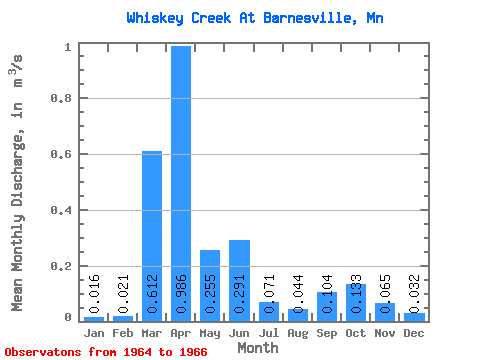
| Statistic | Jan | Feb | Mar | Apr | May | Jun | Jul | Aug | Sep | Oct | Nov | Dec | Annual |
|---|---|---|---|---|---|---|---|---|---|---|---|---|---|
| Mean | 0.02 | 0.02 | 0.61 | 0.99 | 0.26 | 0.29 | 0.07 | 0.04 | 0.10 | 0.13 | 0.07 | 0.03 | 0.24 |
| Standard Deviation | 0.02 | 0.03 | 0.78 | 0.76 | 0.04 | 0.15 | 0.05 | 0.03 | 0.14 | 0.08 | 0.07 | 0.01 | |
| Min | 0.00 | 0.00 | 0.06 | 0.45 | 0.23 | 0.18 | 0.04 | 0.02 | 0.01 | 0.08 | 0.02 | 0.02 | 0.24 |
| Max | 0.03 | 0.04 | 1.17 | 1.53 | 0.28 | 0.40 | 0.11 | 0.07 | 0.20 | 0.19 | 0.11 | 0.04 | 0.24 |
| Coefficient of Variation | 1.22 | 1.29 | 1.28 | 0.77 | 0.14 | 0.52 | 0.71 | 0.72 | 1.29 | 0.60 | 1.05 | 0.35 |
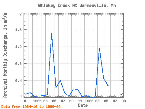
| Year | Jan | Feb | Mar | Apr | May | Jun | Jul | Aug | Sep | Oct | Nov | Dec | Annual | 1964 | 0.08 | 0.11 | 0.02 | 1965 | 0.03 | 0.04 | 0.06 | 1.53 | 0.23 | 0.40 | 0.11 | 0.02 | 0.20 | 0.19 | 0.02 | 0.04 | 0.24 | 1966 | 0.00 | 0.00 | 1.17 | 0.45 | 0.28 | 0.18 | 0.04 | 0.07 | 0.01 |
|---|
 Return to R-Arctic Net Home Page