|
|
|||||||||||||||||
| Point ID: 9542 | Downloads | Plots | Site Data | Code: 05061200 |
|
|
|||||||||||||||||
| Download | |
|---|---|
| Site Descriptor Information | Site Time Series Data |
| Link to all available data | |
|
|
| View: | Statistics | Time Series |
| Units: | m3/s |
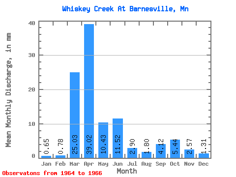
| Statistic | Jan | Feb | Mar | Apr | May | Jun | Jul | Aug | Sep | Oct | Nov | Dec | Annual |
|---|---|---|---|---|---|---|---|---|---|---|---|---|---|
| Mean | 0.21 | 0.26 | 8.29 | 12.94 | 3.46 | 3.82 | 0.95 | 0.60 | 1.36 | 1.80 | 0.85 | 0.43 | 37.99 |
| Standard Deviation | 0.26 | 0.34 | 10.62 | 10.01 | 0.48 | 1.98 | 0.68 | 0.43 | 1.76 | 1.08 | 0.90 | 0.15 | |
| Min | 0.03 | 0.02 | 0.78 | 5.85 | 3.12 | 2.41 | 0.47 | 0.29 | 0.12 | 1.03 | 0.22 | 0.33 | 37.99 |
| Max | 0.40 | 0.50 | 15.80 | 20.02 | 3.79 | 5.22 | 1.44 | 0.91 | 2.61 | 2.56 | 1.49 | 0.54 | 37.99 |
| Coefficient of Variation | 1.22 | 1.29 | 1.28 | 0.77 | 0.14 | 0.52 | 0.71 | 0.72 | 1.29 | 0.60 | 1.05 | 0.35 |
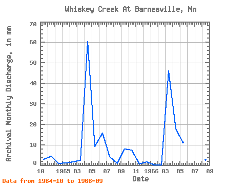
| Year | Jan | Feb | Mar | Apr | May | Jun | Jul | Aug | Sep | Oct | Nov | Dec | Annual | 1964 | 1.03 | 1.49 | 0.33 | 1965 | 0.40 | 0.50 | 0.78 | 20.02 | 3.12 | 5.22 | 1.44 | 0.29 | 2.61 | 2.56 | 0.22 | 0.54 | 37.99 | 1966 | 0.03 | 0.02 | 15.80 | 5.85 | 3.79 | 2.41 | 0.47 | 0.91 | 0.12 |
|---|
 Return to R-Arctic Net Home Page