|
|
|||||||||||||||||
| Point ID: 9541 | Downloads | Plots | Site Data | Code: 05030150 |
|
|
|||||||||||||||||
| Download | |
|---|---|
| Site Descriptor Information | Site Time Series Data |
| Link to all available data | |
|
|
| View: | Statistics | Time Series |
| Units: | mm |
| Statistic | Jan | Feb | Mar | Apr | May | Jun | Jul | Aug | Sep | Oct | Nov | Dec | Annual |
|---|---|---|---|---|---|---|---|---|---|---|---|---|---|
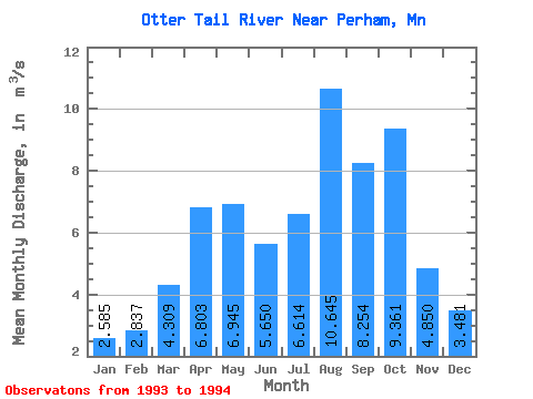
| Mean | 2.58 | 2.84 | 4.31 | 6.80 | 6.95 | 5.65 | 6.61 | 10.64 | 8.25 | 9.36 | 4.85 | 3.48 | |
| Standard Deviation | 0.15 | 0.99 | 0.36 | 0.16 | 0.35 | 2.37 | 9.08 | 7.58 | |||||
| Min | 2.58 | 2.73 | 3.61 | 6.55 | 6.83 | 5.41 | 4.94 | 4.23 | 2.90 | 9.36 | 4.85 | 3.48 | |
| Max | 2.58 | 2.94 | 5.01 | 7.05 | 7.06 | 5.89 | 8.29 | 17.07 | 13.61 | 9.36 | 4.85 | 3.48 | |
| Coefficient of Variation | 0.05 | 0.23 | 0.05 | 0.02 | 0.06 | 0.36 | 0.85 | 0.92 |
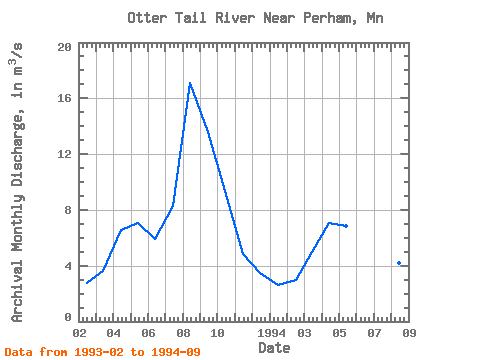
| Year | Jan | Feb | Mar | Apr | May | Jun | Jul | Aug | Sep | Oct | Nov | Dec | Annual | 1993 | 2.73 | 3.61 | 6.55 | 7.06 | 5.89 | 8.29 | 17.07 | 13.61 | 9.36 | 4.85 | 3.48 | 1994 | 2.58 | 2.94 | 5.01 | 7.05 | 6.83 | 5.41 | 4.94 | 4.23 | 2.90 |
|---|
 Return to R-Arctic Net Home Page