|
|
|||||||||||||||||
| Point ID: 9541 | Downloads | Plots | Site Data | Code: 05030150 |
|
|
|||||||||||||||||
| Download | |
|---|---|
| Site Descriptor Information | Site Time Series Data |
| Link to all available data | |
|
|
| View: | Statistics | Time Series |
| Units: | m3/s |
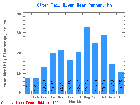
| Statistic | Jan | Feb | Mar | Apr | May | Jun | Jul | Aug | Sep | Oct | Nov | Dec | Annual |
|---|---|---|---|---|---|---|---|---|---|---|---|---|---|
| Mean | 7.98 | 7.98 | 13.30 | 20.32 | 21.44 | 16.88 | 20.41 | 32.86 | 24.66 | 28.89 | 14.49 | 10.74 | |
| Standard Deviation | 0.41 | 3.05 | 1.06 | 0.50 | 1.03 | 7.30 | 28.02 | 22.63 | |||||
| Min | 7.98 | 7.68 | 11.15 | 19.57 | 21.08 | 16.15 | 15.25 | 13.04 | 8.65 | 28.89 | 14.49 | 10.74 | |
| Max | 7.98 | 8.27 | 15.45 | 21.08 | 21.80 | 17.61 | 25.58 | 52.67 | 40.66 | 28.89 | 14.49 | 10.74 | |
| Coefficient of Variation | 0.05 | 0.23 | 0.05 | 0.02 | 0.06 | 0.36 | 0.85 | 0.92 |
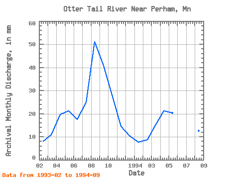
| Year | Jan | Feb | Mar | Apr | May | Jun | Jul | Aug | Sep | Oct | Nov | Dec | Annual | 1993 | 7.68 | 11.15 | 19.57 | 21.80 | 17.61 | 25.58 | 52.67 | 40.66 | 28.89 | 14.49 | 10.74 | 1994 | 7.98 | 8.27 | 15.45 | 21.08 | 21.08 | 16.15 | 15.25 | 13.04 | 8.65 |
|---|
 Return to R-Arctic Net Home Page