|
|
|||||||||||||||||
| Point ID: 9525 | Downloads | Plots | Site Data | Code: 15294010 |
|
|
|||||||||||||||||
| Download | |
|---|---|
| Site Descriptor Information | Site Time Series Data |
| Link to all available data | |
| View: | Time Series | All |
| Units: | m3/s |
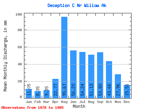
| Statistic | Jan | Feb | Mar | Apr | May | Jun | Jul | Aug | Sep | Oct | Nov | Dec | Annual |
|---|---|---|---|---|---|---|---|---|---|---|---|---|---|
| Mean | 11.04 | 8.43 | 9.35 | 22.77 | 95.66 | 56.19 | 54.22 | 51.13 | 53.81 | 43.66 | 27.96 | 15.52 | 463.59 |
| Standard Deviation | 5.19 | 3.60 | 4.94 | 16.18 | 50.13 | 21.54 | 26.39 | 32.56 | 32.47 | 21.25 | 26.96 | 8.30 | 112.46 |
| Min | 4.12 | 2.87 | 1.77 | 5.56 | 43.60 | 28.78 | 17.06 | 15.96 | 18.74 | 16.87 | 10.21 | 2.51 | 316.72 |
| Max | 20.18 | 13.05 | 15.37 | 45.33 | 190.92 | 97.69 | 86.87 | 114.85 | 120.02 | 77.14 | 87.86 | 28.04 | 618.70 |
| Coefficient of Variation | 0.47 | 0.43 | 0.53 | 0.71 | 0.52 | 0.38 | 0.49 | 0.64 | 0.60 | 0.49 | 0.96 | 0.54 | 0.24 |
 Return to R-Arctic Net Home Page