|
|
|||||||||||||||||
| Point ID: 9525 | Downloads | Plots | Site Data | Code: 15294010 |
|
|
|||||||||||||||||
| Download | |
|---|---|
| Site Descriptor Information | Site Time Series Data |
| Link to all available data | |
| View: | Time Series | All |
| Units: | mm |
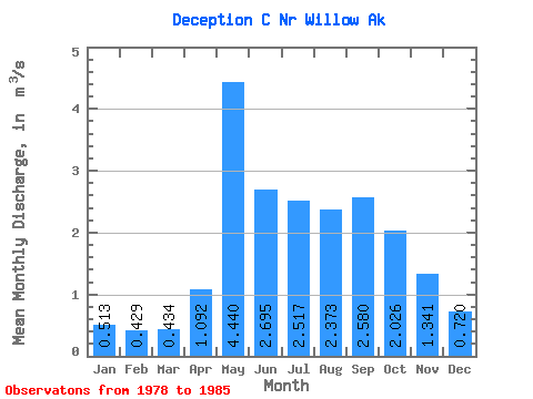
| Statistic | Jan | Feb | Mar | Apr | May | Jun | Jul | Aug | Sep | Oct | Nov | Dec | Annual |
|---|---|---|---|---|---|---|---|---|---|---|---|---|---|
| Mean | 0.51 | 0.43 | 0.43 | 1.09 | 4.44 | 2.69 | 2.52 | 2.37 | 2.58 | 2.03 | 1.34 | 0.72 | 1.83 |
| Standard Deviation | 0.24 | 0.18 | 0.23 | 0.78 | 2.33 | 1.03 | 1.23 | 1.51 | 1.56 | 0.99 | 1.29 | 0.39 | 0.44 |
| Min | 0.19 | 0.15 | 0.08 | 0.27 | 2.02 | 1.38 | 0.79 | 0.74 | 0.90 | 0.78 | 0.49 | 0.12 | 1.25 |
| Max | 0.94 | 0.67 | 0.71 | 2.17 | 8.86 | 4.69 | 4.03 | 5.33 | 5.76 | 3.58 | 4.21 | 1.30 | 2.44 |
| Coefficient of Variation | 0.47 | 0.43 | 0.53 | 0.71 | 0.52 | 0.38 | 0.49 | 0.64 | 0.60 | 0.49 | 0.96 | 0.54 | 0.24 |
 Return to R-Arctic Net Home Page