|
|
|||||||||||||||||
| Point ID: 9520 | Downloads | Plots | Site Data | Code: 15291500 |
|
|
|||||||||||||||||
| Download | |
|---|---|
| Site Descriptor Information | Site Time Series Data |
| Link to all available data | |
|
|
| View: | Statistics | Time Series |
| Units: | mm |
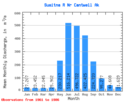
| Statistic | Jan | Feb | Mar | Apr | May | Jun | Jul | Aug | Sep | Oct | Nov | Dec | Annual |
|---|---|---|---|---|---|---|---|---|---|---|---|---|---|
| Mean | 27.21 | 23.45 | 22.05 | 25.90 | 230.22 | 516.21 | 496.72 | 422.43 | 224.72 | 95.28 | 44.61 | 31.64 | 178.54 |
| Standard Deviation | 10.08 | 8.59 | 8.27 | 8.23 | 80.03 | 157.08 | 77.87 | 117.27 | 68.51 | 29.57 | 13.90 | 9.85 | 30.66 |
| Min | 12.37 | 12.05 | 12.15 | 13.17 | 54.21 | 280.60 | 345.92 | 186.82 | 95.60 | 46.38 | 22.09 | 15.38 | 115.19 |
| Max | 47.96 | 42.48 | 41.93 | 39.74 | 344.03 | 980.52 | 645.35 | 644.62 | 365.53 | 154.96 | 70.42 | 46.95 | 228.87 |
| Coefficient of Variation | 0.37 | 0.37 | 0.38 | 0.32 | 0.35 | 0.30 | 0.16 | 0.28 | 0.30 | 0.31 | 0.31 | 0.31 | 0.17 |
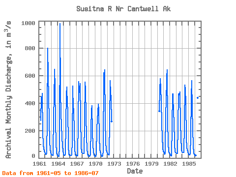
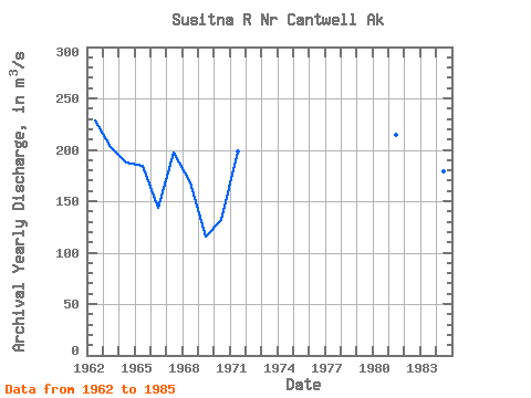
| Year | Jan | Feb | Mar | Apr | May | Jun | Jul | Aug | Sep | Oct | Nov | Dec | Annual | 1961 | 274.33 | 444.74 | 419.64 | 472.75 | 190.42 | 92.90 | 50.97 | 39.64 | 1962 | 36.81 | 28.32 | 26.62 | 33.98 | 283.17 | 802.03 | 591.55 | 453.07 | 266.46 | 122.49 | 62.30 | 39.64 | 228.87 | 1963 | 28.32 | 24.07 | 21.52 | 20.39 | 321.08 | 424.75 | 645.35 | 515.00 | 260.14 | 108.96 | 36.81 | 24.84 | 202.60 | 1964 | 18.23 | 16.59 | 12.15 | 13.17 | 79.47 | 980.52 | 482.57 | 325.83 | 151.56 | 88.74 | 54.10 | 26.09 | 187.42 | 1965 | 21.52 | 19.25 | 20.09 | 31.05 | 249.71 | 465.34 | 519.57 | 380.59 | 365.53 | 88.24 | 28.32 | 21.24 | 184.20 | 1966 | 19.82 | 18.41 | 18.41 | 24.78 | 124.23 | 523.86 | 345.92 | 358.98 | 184.71 | 65.74 | 22.09 | 20.39 | 143.94 | 1967 | 19.25 | 18.12 | 15.86 | 14.54 | 267.64 | 555.67 | 478.10 | 543.41 | 291.00 | 87.33 | 42.19 | 37.73 | 197.57 | 1968 | 34.89 | 33.98 | 33.98 | 34.64 | 262.43 | 552.18 | 495.09 | 309.66 | 153.19 | 68.14 | 30.11 | 17.49 | 168.82 | 1969 | 14.39 | 13.73 | 15.52 | 28.27 | 211.55 | 349.06 | 382.51 | 186.82 | 95.60 | 46.38 | 23.08 | 15.38 | 115.19 | 1970 | 12.37 | 12.05 | 13.12 | 25.11 | 214.63 | 280.60 | 393.60 | 348.96 | 147.57 | 61.02 | 43.33 | 29.69 | 131.84 | 1971 | 20.69 | 14.25 | 13.30 | 14.97 | 54.21 | 622.03 | 513.36 | 643.07 | 277.50 | 114.91 | 58.05 | 38.82 | 198.76 | 1972 | 30.23 | 26.11 | 24.94 | 24.80 | 274.49 | 566.24 | 472.53 | 442.38 | 266.84 | 1980 | 343.58 | 491.96 | 579.40 | 420.97 | 242.67 | 154.96 | 70.42 | 46.95 | 1981 | 47.96 | 33.58 | 26.03 | 34.50 | 344.03 | 396.91 | 591.04 | 644.62 | 266.67 | 108.43 | 46.06 | 36.72 | 214.71 | 1982 | 30.05 | 19.75 | 16.21 | 16.23 | 232.75 | 467.13 | 468.23 | 311.65 | 281.52 | 93.69 | 45.31 | 39.64 | 168.51 | 1983 | 36.81 | 33.98 | 32.52 | 34.26 | 232.08 | 466.00 | 460.01 | 481.48 | 245.11 | 152.27 | 60.31 | 45.31 | 190.01 | 1984 | 42.48 | 42.48 | 41.93 | 39.74 | 242.70 | 532.73 | 501.21 | 403.83 | 145.47 | 78.10 | 46.20 | 33.04 | 179.16 | 1985 | 28.03 | 24.92 | 23.90 | 29.10 | 156.89 | 447.60 | 563.05 | 360.58 | 213.00 | 87.42 | 38.70 | 25.24 | 166.54 | 1986 | 20.65 | 19.09 | 18.69 | 20.80 | 205.16 | 438.72 | 535.01 |
|---|
 Return to R-Arctic Net Home Page