|
|
|||||||||||||||||
| Point ID: 9520 | Downloads | Plots | Site Data | Code: 15291500 |
|
|
|||||||||||||||||
| Download | |
|---|---|
| Site Descriptor Information | Site Time Series Data |
| Link to all available data | |
| View: | Time Series | All |
| Units: | mm |
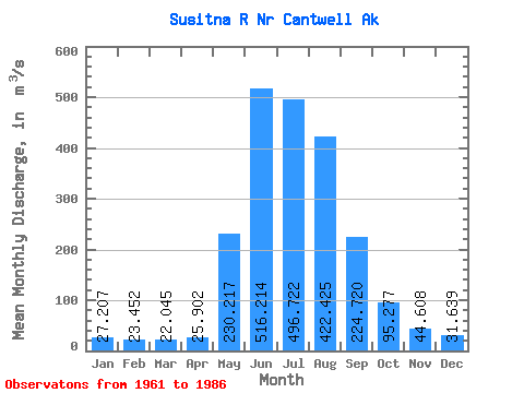
| Statistic | Jan | Feb | Mar | Apr | May | Jun | Jul | Aug | Sep | Oct | Nov | Dec | Annual |
|---|---|---|---|---|---|---|---|---|---|---|---|---|---|
| Mean | 27.21 | 23.45 | 22.05 | 25.90 | 230.22 | 516.21 | 496.72 | 422.43 | 224.72 | 95.28 | 44.61 | 31.64 | 178.54 |
| Standard Deviation | 10.08 | 8.59 | 8.27 | 8.23 | 80.03 | 157.08 | 77.87 | 117.27 | 68.51 | 29.57 | 13.90 | 9.85 | 30.66 |
| Min | 12.37 | 12.05 | 12.15 | 13.17 | 54.21 | 280.60 | 345.92 | 186.82 | 95.60 | 46.38 | 22.09 | 15.38 | 115.19 |
| Max | 47.96 | 42.48 | 41.93 | 39.74 | 344.03 | 980.52 | 645.35 | 644.62 | 365.53 | 154.96 | 70.42 | 46.95 | 228.87 |
| Coefficient of Variation | 0.37 | 0.37 | 0.38 | 0.32 | 0.35 | 0.30 | 0.16 | 0.28 | 0.30 | 0.31 | 0.31 | 0.31 | 0.17 |
 Return to R-Arctic Net Home Page