|
|
|||||||||||||||||
| Point ID: 9516 | Downloads | Plots | Site Data | Code: 15294300 |
|
|
|||||||||||||||||
| Download | |
|---|---|
| Site Descriptor Information | Site Time Series Data |
| Link to all available data | |
|
|
| View: | Statistics | Time Series |
| Units: | mm |
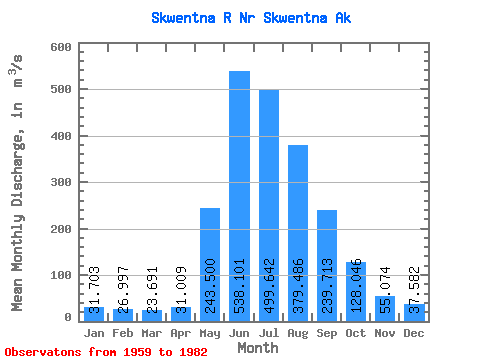
| Statistic | Jan | Feb | Mar | Apr | May | Jun | Jul | Aug | Sep | Oct | Nov | Dec | Annual |
|---|---|---|---|---|---|---|---|---|---|---|---|---|---|
| Mean | 31.70 | 27.00 | 23.69 | 31.01 | 243.50 | 538.10 | 499.64 | 379.49 | 239.71 | 128.05 | 55.07 | 37.58 | 187.03 |
| Standard Deviation | 12.63 | 8.34 | 5.82 | 12.27 | 123.46 | 166.83 | 113.31 | 81.71 | 78.12 | 35.38 | 19.85 | 13.40 | 34.09 |
| Min | 16.99 | 16.99 | 16.99 | 17.18 | 46.31 | 301.67 | 330.51 | 211.54 | 107.12 | 54.63 | 19.21 | 17.68 | 143.68 |
| Max | 80.11 | 51.58 | 38.27 | 60.55 | 633.38 | 1038.38 | 810.32 | 570.82 | 429.10 | 205.42 | 118.78 | 81.30 | 278.61 |
| Coefficient of Variation | 0.40 | 0.31 | 0.25 | 0.40 | 0.51 | 0.31 | 0.23 | 0.21 | 0.33 | 0.28 | 0.36 | 0.36 | 0.18 |
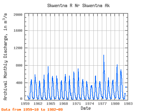
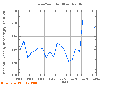
| Year | Jan | Feb | Mar | Apr | May | Jun | Jul | Aug | Sep | Oct | Nov | Dec | Annual | 1959 | 100.02 | 52.39 | 39.64 | 1960 | 31.06 | 27.20 | 23.88 | 23.64 | 296.87 | 380.67 | 472.53 | 452.70 | 259.69 | 110.13 | 45.31 | 45.22 | 180.74 | 1961 | 39.73 | 32.67 | 32.70 | 48.14 | 317.32 | 582.57 | 466.77 | 393.81 | 340.41 | 130.39 | 62.30 | 39.64 | 207.21 | 1962 | 33.98 | 24.35 | 21.52 | 28.32 | 187.26 | 442.69 | 422.74 | 342.09 | 190.38 | 79.31 | 35.40 | 31.15 | 153.26 | 1963 | 28.32 | 22.94 | 19.82 | 18.41 | 219.87 | 397.77 | 578.49 | 340.49 | 203.31 | 151.65 | 43.89 | 23.79 | 170.73 | 1964 | 27.47 | 21.24 | 16.99 | 23.79 | 46.31 | 771.73 | 466.77 | 359.17 | 176.24 | 125.32 | 50.69 | 36.81 | 176.88 | 1965 | 26.05 | 22.65 | 20.95 | 21.80 | 136.19 | 485.92 | 548.52 | 396.58 | 370.55 | 116.73 | 44.60 | 32.56 | 185.26 | 1966 | 31.15 | 31.15 | 31.15 | 36.81 | 127.48 | 553.71 | 401.62 | 490.32 | 277.83 | 157.89 | 39.64 | 25.48 | 183.69 | 1967 | 20.39 | 18.41 | 18.41 | 22.09 | 50.79 | 408.67 | 417.44 | 446.40 | 269.48 | 108.50 | 44.17 | 33.43 | 154.85 | 1968 | 28.96 | 28.32 | 26.90 | 36.62 | 381.27 | 588.14 | 495.00 | 298.92 | 109.17 | 54.63 | 19.21 | 17.68 | 173.73 | 1969 | 16.99 | 16.99 | 17.72 | 42.10 | 313.33 | 554.54 | 386.62 | 211.54 | 107.12 | 160.11 | 45.52 | 23.57 | 158.01 | 1970 | 21.69 | 19.82 | 18.41 | 20.62 | 331.58 | 647.98 | 598.12 | 369.10 | 188.72 | 82.65 | 57.29 | 33.52 | 199.13 | 1971 | 24.48 | 20.43 | 17.36 | 17.18 | 168.85 | 719.34 | 583.42 | 450.69 | 170.58 | 85.53 | 37.57 | 31.24 | 193.89 | 1972 | 28.00 | 25.44 | 22.97 | 21.00 | 227.81 | 434.10 | 476.91 | 378.72 | 262.11 | 128.87 | 66.26 | 37.27 | 175.79 | 1973 | 25.76 | 19.87 | 17.17 | 20.58 | 179.78 | 430.50 | 392.14 | 279.60 | 174.54 | 100.25 | 48.14 | 35.81 | 143.68 | 1974 | 28.96 | 25.54 | 22.97 | 28.46 | 191.57 | 301.67 | 330.51 | 296.72 | 334.01 | 129.04 | 65.93 | 26.03 | 148.45 | 1975 | 22.65 | 21.24 | 21.24 | 21.71 | 222.33 | 539.72 | 552.82 | 331.73 | 239.87 | 133.20 | 55.88 | 35.62 | 183.17 | 1976 | 27.50 | 25.39 | 22.65 | 35.96 | 249.37 | 428.06 | 412.79 | 314.98 | 231.20 | 175.46 | 81.55 | 81.30 | 173.85 | 1977 | 80.11 | 51.58 | 33.98 | 33.98 | 252.20 | 1038.38 | 715.68 | 570.82 | 291.35 | 164.22 | 67.20 | 43.85 | 278.61 | 1978 | 34.35 | 26.73 | 23.82 | 28.98 | 255.03 | 391.90 | 512.53 | 389.12 | 211.76 | 139.77 | 44.73 | 44.03 | 175.23 | 1979 | 32.98 | 29.33 | 27.79 | 45.23 | 330.23 | 424.28 | 448.23 | 458.92 | 210.91 | 205.42 | 118.78 | 63.03 | 199.59 | 1980 | 50.42 | 45.80 | 38.27 | 55.42 | 335.43 | 701.79 | 810.32 | 392.54 | 248.75 | 159.37 | 76.08 | 41.79 | 246.33 | 1981 | 35.03 | 35.95 | 26.21 | 60.55 | 633.38 | 698.67 | 605.98 | 467.01 | 216.31 | 146.61 | 64.19 | 41.93 | 252.65 | 1982 | 33.16 | 27.91 | 22.01 | 21.81 | 146.24 | 453.54 | 395.80 | 296.21 | 429.10 |
|---|
 Return to R-Arctic Net Home Page