|
|
|||||||||||||||||
| Point ID: 9516 | Downloads | Plots | Site Data | Code: 15294300 |
|
|
|||||||||||||||||
| Download | |
|---|---|
| Site Descriptor Information | Site Time Series Data |
| Link to all available data | |
| View: | Time Series | All |
| Units: | mm |
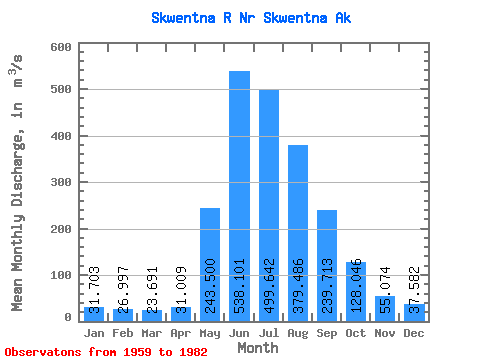
| Statistic | Jan | Feb | Mar | Apr | May | Jun | Jul | Aug | Sep | Oct | Nov | Dec | Annual |
|---|---|---|---|---|---|---|---|---|---|---|---|---|---|
| Mean | 31.70 | 27.00 | 23.69 | 31.01 | 243.50 | 538.10 | 499.64 | 379.49 | 239.71 | 128.05 | 55.07 | 37.58 | 187.03 |
| Standard Deviation | 12.63 | 8.34 | 5.82 | 12.27 | 123.46 | 166.83 | 113.31 | 81.71 | 78.12 | 35.38 | 19.85 | 13.40 | 34.09 |
| Min | 16.99 | 16.99 | 16.99 | 17.18 | 46.31 | 301.67 | 330.51 | 211.54 | 107.12 | 54.63 | 19.21 | 17.68 | 143.68 |
| Max | 80.11 | 51.58 | 38.27 | 60.55 | 633.38 | 1038.38 | 810.32 | 570.82 | 429.10 | 205.42 | 118.78 | 81.30 | 278.61 |
| Coefficient of Variation | 0.40 | 0.31 | 0.25 | 0.40 | 0.51 | 0.31 | 0.23 | 0.21 | 0.33 | 0.28 | 0.36 | 0.36 | 0.18 |
 Return to R-Arctic Net Home Page