|
|
|||||||||||||||||
| Point ID: 9514 | Downloads | Plots | Site Data | Code: 15294345 |
|
|
|||||||||||||||||
| Download | |
|---|---|
| Site Descriptor Information | Site Time Series Data |
| Link to all available data | |
|
|
| View: | Statistics | Time Series |
| Units: | mm |
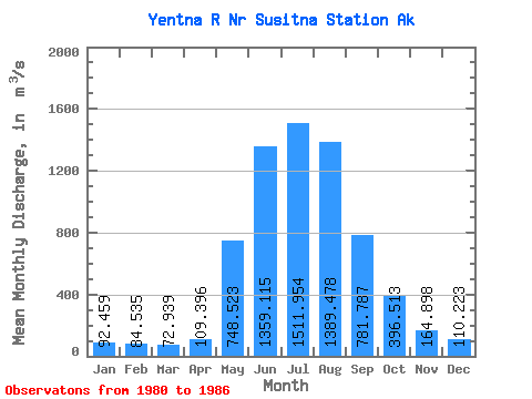
| Statistic | Jan | Feb | Mar | Apr | May | Jun | Jul | Aug | Sep | Oct | Nov | Dec | Annual |
|---|---|---|---|---|---|---|---|---|---|---|---|---|---|
| Mean | 92.46 | 84.53 | 72.94 | 109.40 | 748.52 | 1359.12 | 1511.95 | 1389.48 | 781.79 | 396.51 | 164.90 | 110.22 | 568.68 |
| Standard Deviation | 11.67 | 13.42 | 9.05 | 44.28 | 312.43 | 137.69 | 233.35 | 206.70 | 353.30 | 81.66 | 39.79 | 15.96 | 67.32 |
| Min | 74.63 | 65.36 | 63.03 | 61.64 | 393.69 | 1157.40 | 1263.57 | 1125.73 | 446.07 | 304.18 | 123.84 | 85.32 | 509.83 |
| Max | 105.05 | 105.78 | 87.42 | 162.95 | 1292.25 | 1560.73 | 1823.15 | 1666.67 | 1347.79 | 524.87 | 236.92 | 128.52 | 681.04 |
| Coefficient of Variation | 0.13 | 0.16 | 0.12 | 0.41 | 0.42 | 0.10 | 0.15 | 0.15 | 0.45 | 0.21 | 0.24 | 0.14 | 0.12 |
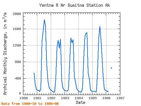
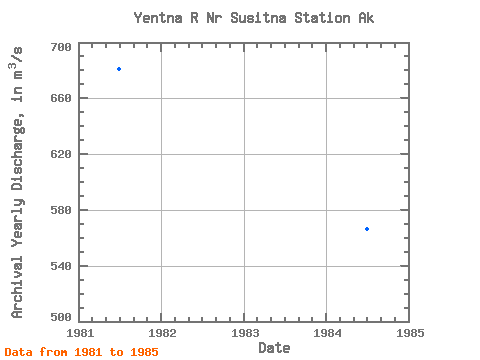
| Year | Jan | Feb | Mar | Apr | May | Jun | Jul | Aug | Sep | Oct | Nov | Dec | Annual | 1980 | 524.87 | 236.92 | 123.68 | 1981 | 105.05 | 105.78 | 77.83 | 155.18 | 1292.25 | 1560.73 | 1823.15 | 1666.67 | 733.22 | 347.22 | 176.89 | 128.52 | 681.04 | 1982 | 103.68 | 80.70 | 63.03 | 61.64 | 393.69 | 1157.40 | 1323.49 | 1125.73 | 1347.79 | 354.14 | 160.37 | 116.56 | 524.02 | 1983 | 94.56 | 91.62 | 87.42 | 125.11 | 733.50 | 1381.77 | 1263.57 | 1334.73 | 446.07 | 304.18 | 154.14 | 101.30 | 509.83 | 1984 | 74.63 | 65.36 | 64.49 | 162.95 | 874.44 | 1418.49 | 1485.72 | 1511.75 | 537.08 | 388.48 | 123.84 | 85.32 | 566.05 | 1985 | 83.86 | 80.70 | 74.17 | 70.79 | 546.24 | 1373.18 | 1663.84 | 1308.51 | 844.79 | 460.19 | 137.24 | 105.96 | 562.46 | 1986 | 92.99 | 83.03 | 70.70 | 80.70 | 651.01 | 1263.12 |
|---|
 Return to R-Arctic Net Home Page