|
|
|||||||||||||||||
| Point ID: 9514 | Downloads | Plots | Site Data | Code: 15294345 |
|
|
|||||||||||||||||
| Download | |
|---|---|
| Site Descriptor Information | Site Time Series Data |
| Link to all available data | |
|
|
| View: | Statistics | Time Series |
| Units: | m3/s |
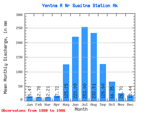
| Statistic | Jan | Feb | Mar | Apr | May | Jun | Jul | Aug | Sep | Oct | Nov | Dec | Annual |
|---|---|---|---|---|---|---|---|---|---|---|---|---|---|
| Mean | 15.47 | 12.89 | 12.20 | 17.71 | 125.24 | 220.09 | 252.97 | 232.47 | 126.60 | 66.34 | 26.70 | 18.44 | 1121.29 |
| Standard Deviation | 1.95 | 2.05 | 1.51 | 7.17 | 52.27 | 22.30 | 39.04 | 34.58 | 57.21 | 13.66 | 6.44 | 2.67 | 132.74 |
| Min | 12.49 | 9.96 | 10.54 | 9.98 | 65.87 | 187.43 | 211.41 | 188.35 | 72.23 | 50.89 | 20.05 | 14.27 | 1005.26 |
| Max | 17.57 | 16.13 | 14.63 | 26.39 | 216.21 | 252.74 | 305.03 | 278.85 | 218.26 | 87.82 | 38.37 | 21.50 | 1342.84 |
| Coefficient of Variation | 0.13 | 0.16 | 0.12 | 0.41 | 0.42 | 0.10 | 0.15 | 0.15 | 0.45 | 0.21 | 0.24 | 0.14 | 0.12 |
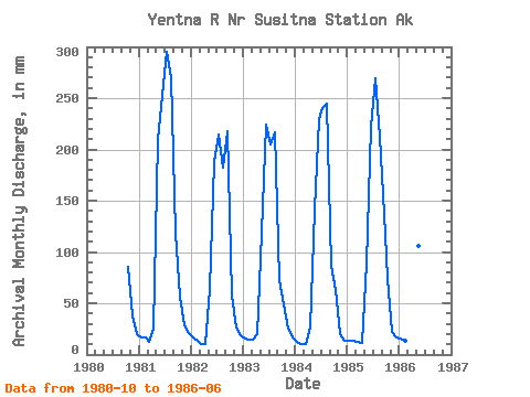
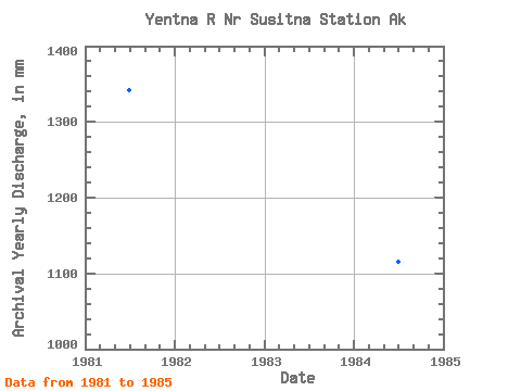
| Year | Jan | Feb | Mar | Apr | May | Jun | Jul | Aug | Sep | Oct | Nov | Dec | Annual | 1980 | 87.82 | 38.37 | 20.69 | 1981 | 17.57 | 16.13 | 13.02 | 25.13 | 216.21 | 252.74 | 305.03 | 278.85 | 118.74 | 58.09 | 28.64 | 21.50 | 1342.84 | 1982 | 17.35 | 12.30 | 10.54 | 9.98 | 65.87 | 187.43 | 221.44 | 188.35 | 218.26 | 59.25 | 25.97 | 19.50 | 1033.23 | 1983 | 15.82 | 13.97 | 14.63 | 20.26 | 122.72 | 223.76 | 211.41 | 223.31 | 72.23 | 50.89 | 24.96 | 16.95 | 1005.26 | 1984 | 12.49 | 9.96 | 10.79 | 26.39 | 146.30 | 229.71 | 248.58 | 252.93 | 86.97 | 65.00 | 20.05 | 14.27 | 1116.10 | 1985 | 14.03 | 12.30 | 12.41 | 11.46 | 91.39 | 222.37 | 278.38 | 218.93 | 136.80 | 77.00 | 22.23 | 17.73 | 1109.02 | 1986 | 15.56 | 12.66 | 11.83 | 13.07 | 108.92 | 204.55 |
|---|
 Return to R-Arctic Net Home Page