|
|
|||||||||||||||||
| Point ID: 9504 | Downloads | Plots | Site Data | Code: 15238985 |
|
|
|||||||||||||||||
| Download | |
|---|---|
| Site Descriptor Information | Site Time Series Data |
| Link to all available data | |
|
|
| View: | Statistics | Time Series |
| Units: | mm |
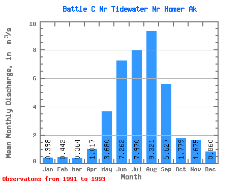
| Statistic | Jan | Feb | Mar | Apr | May | Jun | Jul | Aug | Sep | Oct | Nov | Dec | Annual |
|---|---|---|---|---|---|---|---|---|---|---|---|---|---|
| Mean | 0.40 | 0.44 | 0.36 | 1.02 | 3.68 | 7.26 | 7.97 | 9.32 | 5.63 | 1.78 | 1.68 | 0.86 | 3.06 |
| Standard Deviation | 0.10 | 0.12 | 0.08 | 0.58 | 0.75 | 1.05 | 0.41 | 1.52 | 3.86 | 0.28 | 1.23 | 0.65 | |
| Min | 0.33 | 0.36 | 0.31 | 0.61 | 3.15 | 6.52 | 7.54 | 8.28 | 1.73 | 1.58 | 0.80 | 0.40 | 3.06 |
| Max | 0.47 | 0.53 | 0.42 | 1.43 | 4.21 | 8.00 | 8.37 | 11.07 | 9.45 | 1.98 | 2.55 | 1.32 | 3.06 |
| Coefficient of Variation | 0.25 | 0.27 | 0.22 | 0.57 | 0.20 | 0.14 | 0.05 | 0.16 | 0.69 | 0.16 | 0.74 | 0.76 |
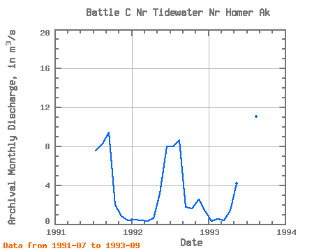
| Year | Jan | Feb | Mar | Apr | May | Jun | Jul | Aug | Sep | Oct | Nov | Dec | Annual | 1991 | 7.54 | 8.28 | 9.45 | 1.98 | 0.80 | 0.40 | 1992 | 0.47 | 0.36 | 0.31 | 0.61 | 3.15 | 8.00 | 8.01 | 8.62 | 1.73 | 1.58 | 2.55 | 1.32 | 3.06 | 1993 | 0.33 | 0.53 | 0.42 | 1.43 | 4.21 | 6.52 | 8.37 | 11.07 | 5.70 |
|---|
 Return to R-Arctic Net Home Page