|
|
|||||||||||||||||
| Point ID: 9504 | Downloads | Plots | Site Data | Code: 15238985 |
|
|
|||||||||||||||||
| Download | |
|---|---|
| Site Descriptor Information | Site Time Series Data |
| Link to all available data | |
|
|
| View: | Statistics | Time Series |
| Units: | m3/s |
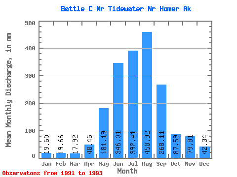
| Statistic | Jan | Feb | Mar | Apr | May | Jun | Jul | Aug | Sep | Oct | Nov | Dec | Annual |
|---|---|---|---|---|---|---|---|---|---|---|---|---|---|
| Mean | 19.59 | 19.83 | 17.90 | 48.45 | 181.17 | 346.03 | 392.36 | 458.87 | 268.12 | 87.60 | 79.79 | 42.33 | 1774.17 |
| Standard Deviation | 4.83 | 5.25 | 3.93 | 27.58 | 36.95 | 49.86 | 20.43 | 75.06 | 183.95 | 13.67 | 58.77 | 32.15 | |
| Min | 16.17 | 16.11 | 15.12 | 28.95 | 155.05 | 310.78 | 371.13 | 407.40 | 82.44 | 77.93 | 38.23 | 19.60 | 1774.17 |
| Max | 23.00 | 23.54 | 20.68 | 67.96 | 207.29 | 381.29 | 411.89 | 545.00 | 450.28 | 97.26 | 121.34 | 65.07 | 1774.17 |
| Coefficient of Variation | 0.25 | 0.27 | 0.22 | 0.57 | 0.20 | 0.14 | 0.05 | 0.16 | 0.69 | 0.16 | 0.74 | 0.76 |
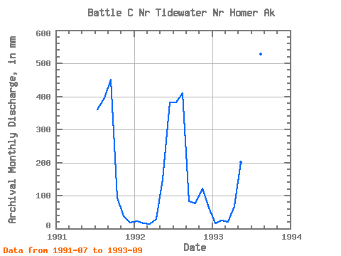
| Year | Jan | Feb | Mar | Apr | May | Jun | Jul | Aug | Sep | Oct | Nov | Dec | Annual | 1991 | 371.13 | 407.40 | 450.28 | 97.26 | 38.23 | 19.60 | 1992 | 23.00 | 16.11 | 15.12 | 28.95 | 155.05 | 381.29 | 394.07 | 424.22 | 82.44 | 77.93 | 121.34 | 65.07 | 1774.17 | 1993 | 16.17 | 23.54 | 20.68 | 67.96 | 207.29 | 310.78 | 411.89 | 545.00 | 271.64 |
|---|
 Return to R-Arctic Net Home Page