|
|
|||||||||||||||||
| Point ID: 9497 | Downloads | Plots | Site Data | Code: 15296950 |
|
|
|||||||||||||||||
| Download | |
|---|---|
| Site Descriptor Information | Site Time Series Data |
| Link to all available data | |
|
|
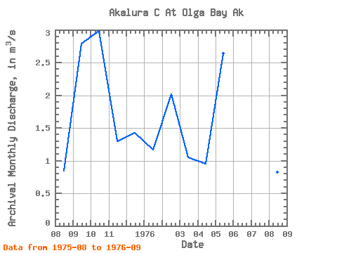
| View: | Statistics | Time Series |
| Units: | mm |
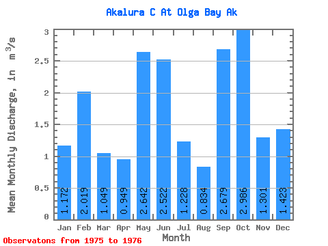
| Statistic | Jan | Feb | Mar | Apr | May | Jun | Jul | Aug | Sep | Oct | Nov | Dec | Annual |
|---|---|---|---|---|---|---|---|---|---|---|---|---|---|
| Mean | 1.17 | 2.02 | 1.05 | 0.95 | 2.64 | 2.52 | 1.23 | 0.83 | 2.68 | 2.99 | 1.30 | 1.42 | |
| Standard Deviation | 0.01 | 0.15 | |||||||||||
| Min | 1.17 | 2.02 | 1.05 | 0.95 | 2.64 | 2.52 | 1.23 | 0.82 | 2.57 | 2.99 | 1.30 | 1.42 | |
| Max | 1.17 | 2.02 | 1.05 | 0.95 | 2.64 | 2.52 | 1.23 | 0.84 | 2.79 | 2.99 | 1.30 | 1.42 | |
| Coefficient of Variation | 0.02 | 0.06 |
| Year | Jan | Feb | Mar | Apr | May | Jun | Jul | Aug | Sep | Oct | Nov | Dec | Annual | 1975 | 0.84 | 2.79 | 2.99 | 1.30 | 1.42 | 1976 | 1.17 | 2.02 | 1.05 | 0.95 | 2.64 | 2.52 | 1.23 | 0.82 | 2.57 |
|---|
 Return to R-Arctic Net Home Page