|
|
|||||||||||||||||
| Point ID: 9497 | Downloads | Plots | Site Data | Code: 15296950 |
|
|
|||||||||||||||||
| Download | |
|---|---|
| Site Descriptor Information | Site Time Series Data |
| Link to all available data | |
|
|
| View: | Statistics | Time Series |
| Units: | m3/s |
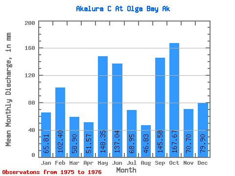
| Statistic | Jan | Feb | Mar | Apr | May | Jun | Jul | Aug | Sep | Oct | Nov | Dec | Annual |
|---|---|---|---|---|---|---|---|---|---|---|---|---|---|
| Mean | 65.79 | 103.30 | 58.90 | 51.55 | 148.31 | 137.05 | 68.94 | 46.84 | 145.59 | 167.65 | 70.68 | 79.89 | |
| Standard Deviation | 0.75 | 8.38 | |||||||||||
| Min | 65.79 | 103.30 | 58.90 | 51.55 | 148.31 | 137.05 | 68.94 | 46.31 | 139.66 | 167.65 | 70.68 | 79.89 | |
| Max | 65.79 | 103.30 | 58.90 | 51.55 | 148.31 | 137.05 | 68.94 | 47.37 | 151.51 | 167.65 | 70.68 | 79.89 | |
| Coefficient of Variation | 0.02 | 0.06 |
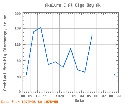
| Year | Jan | Feb | Mar | Apr | May | Jun | Jul | Aug | Sep | Oct | Nov | Dec | Annual | 1975 | 47.37 | 151.51 | 167.65 | 70.68 | 79.89 | 1976 | 65.79 | 103.30 | 58.90 | 51.55 | 148.31 | 137.05 | 68.94 | 46.31 | 139.66 |
|---|
 Return to R-Arctic Net Home Page