|
|
|||||||||||||||||
| Point ID: 9494 | Downloads | Plots | Site Data | Code: 15296520 |
|
|
|||||||||||||||||
| Download | |
|---|---|
| Site Descriptor Information | Site Time Series Data |
| Link to all available data | |
|

|
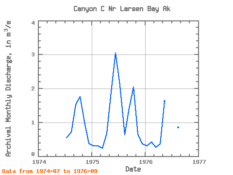
| View: | Statistics | Time Series |
| Units: | mm |
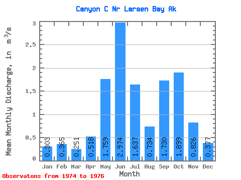
| Statistic | Jan | Feb | Mar | Apr | May | Jun | Jul | Aug | Sep | Oct | Nov | Dec | Annual |
|---|---|---|---|---|---|---|---|---|---|---|---|---|---|
| Mean | 0.30 | 0.36 | 0.25 | 0.52 | 1.76 | 2.97 | 1.64 | 0.73 | 1.73 | 1.90 | 0.83 | 0.38 | 1.14 |
| Standard Deviation | 0.00 | 0.07 | 0.01 | 0.22 | 0.19 | 0.11 | 0.94 | 0.11 | 0.45 | 0.20 | 0.25 | 0.01 | |
| Min | 0.30 | 0.31 | 0.24 | 0.36 | 1.62 | 2.90 | 0.56 | 0.64 | 1.42 | 1.76 | 0.65 | 0.37 | 1.14 |
| Max | 0.30 | 0.42 | 0.26 | 0.67 | 1.89 | 3.05 | 2.25 | 0.86 | 2.25 | 2.04 | 1.00 | 0.39 | 1.14 |
| Coefficient of Variation | 0.00 | 0.20 | 0.06 | 0.42 | 0.11 | 0.04 | 0.57 | 0.15 | 0.26 | 0.10 | 0.31 | 0.04 |
| Year | Jan | Feb | Mar | Apr | May | Jun | Jul | Aug | Sep | Oct | Nov | Dec | Annual | 1974 | 0.56 | 0.71 | 1.53 | 1.76 | 1.00 | 0.39 | 1975 | 0.30 | 0.31 | 0.24 | 0.67 | 1.89 | 3.05 | 2.10 | 0.64 | 1.42 | 2.04 | 0.65 | 0.37 | 1.14 | 1976 | 0.30 | 0.42 | 0.26 | 0.36 | 1.62 | 2.90 | 2.25 | 0.86 | 2.25 |
|---|
 Return to R-Arctic Net Home Page