|
|
|||||||||||||||||
| Point ID: 9494 | Downloads | Plots | Site Data | Code: 15296520 |
|
|
|||||||||||||||||
| Download | |
|---|---|
| Site Descriptor Information | Site Time Series Data |
| Link to all available data | |
|
|
| View: | Statistics | Time Series |
| Units: | m3/s |
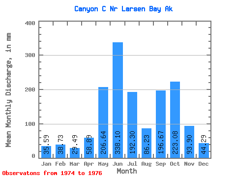
| Statistic | Jan | Feb | Mar | Apr | May | Jun | Jul | Aug | Sep | Oct | Nov | Dec | Annual |
|---|---|---|---|---|---|---|---|---|---|---|---|---|---|
| Mean | 35.57 | 39.08 | 29.52 | 58.92 | 206.63 | 338.13 | 192.24 | 86.26 | 196.69 | 223.06 | 93.90 | 44.25 | 1579.58 |
| Standard Deviation | 0.09 | 7.69 | 1.64 | 25.04 | 22.46 | 12.14 | 110.04 | 12.93 | 51.21 | 23.38 | 28.83 | 1.75 | |
| Min | 35.51 | 33.63 | 28.36 | 41.21 | 190.75 | 329.54 | 65.54 | 75.33 | 161.17 | 206.53 | 73.51 | 43.01 | 1579.58 |
| Max | 35.63 | 44.52 | 30.68 | 76.63 | 222.51 | 346.71 | 263.92 | 100.53 | 255.40 | 239.59 | 114.28 | 45.49 | 1579.58 |
| Coefficient of Variation | 0.00 | 0.20 | 0.06 | 0.42 | 0.11 | 0.04 | 0.57 | 0.15 | 0.26 | 0.10 | 0.31 | 0.04 |
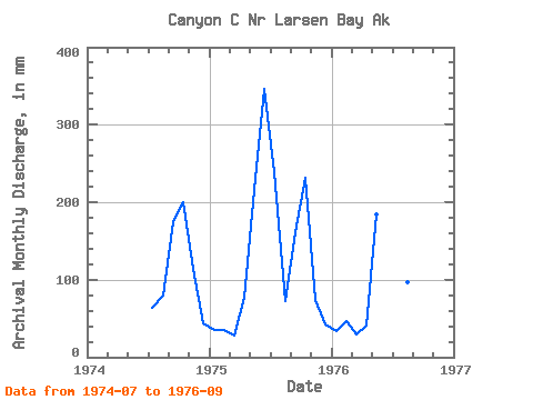
| Year | Jan | Feb | Mar | Apr | May | Jun | Jul | Aug | Sep | Oct | Nov | Dec | Annual | 1974 | 65.54 | 82.93 | 173.51 | 206.53 | 114.28 | 45.49 | 1975 | 35.63 | 33.63 | 28.36 | 76.63 | 222.51 | 346.71 | 247.25 | 75.33 | 161.17 | 239.59 | 73.51 | 43.01 | 1579.58 | 1976 | 35.51 | 44.52 | 30.68 | 41.21 | 190.75 | 329.54 | 263.92 | 100.53 | 255.40 |
|---|
 Return to R-Arctic Net Home Page