|
|
|||||||||||||||||
| Point ID: 9489 | Downloads | Plots | Site Data | Code: 15276500 |
|
|
|||||||||||||||||
| Download | |
|---|---|
| Site Descriptor Information | Site Time Series Data |
| Link to all available data | |
| View: | Time Series | All |
| Units: | m3/s |
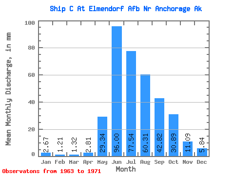
| Statistic | Jan | Feb | Mar | Apr | May | Jun | Jul | Aug | Sep | Oct | Nov | Dec | Annual |
|---|---|---|---|---|---|---|---|---|---|---|---|---|---|
| Mean | 2.67 | 1.22 | 1.32 | 2.81 | 29.34 | 96.00 | 77.53 | 60.30 | 42.82 | 30.89 | 11.09 | 5.84 | 337.80 |
| Standard Deviation | 1.75 | 0.92 | 1.28 | 2.80 | 17.32 | 26.83 | 27.98 | 29.38 | 27.55 | 15.06 | 5.79 | 2.55 | 70.31 |
| Min | 0.44 | 0.32 | 0.32 | 0.32 | 5.25 | 61.35 | 30.46 | 21.24 | 9.93 | 9.30 | 2.50 | 0.59 | 210.58 |
| Max | 4.72 | 2.83 | 3.99 | 8.09 | 58.73 | 148.84 | 131.64 | 116.47 | 95.38 | 47.94 | 19.08 | 8.72 | 423.55 |
| Coefficient of Variation | 0.66 | 0.76 | 0.97 | 1.00 | 0.59 | 0.28 | 0.36 | 0.49 | 0.64 | 0.49 | 0.52 | 0.44 | 0.21 |
 Return to R-Arctic Net Home Page