|
|
|||||||||||||||||
| Point ID: 9489 | Downloads | Plots | Site Data | Code: 15276500 |
|
|
|||||||||||||||||
| Download | |
|---|---|
| Site Descriptor Information | Site Time Series Data |
| Link to all available data | |
| View: | Time Series | All |
| Units: | mm |
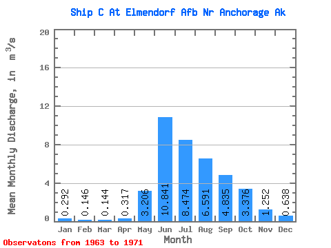
| Statistic | Jan | Feb | Mar | Apr | May | Jun | Jul | Aug | Sep | Oct | Nov | Dec | Annual |
|---|---|---|---|---|---|---|---|---|---|---|---|---|---|
| Mean | 0.29 | 0.15 | 0.14 | 0.32 | 3.21 | 10.84 | 8.47 | 6.59 | 4.83 | 3.38 | 1.25 | 0.64 | 3.13 |
| Standard Deviation | 0.19 | 0.11 | 0.14 | 0.32 | 1.89 | 3.03 | 3.06 | 3.21 | 3.11 | 1.65 | 0.65 | 0.28 | 0.65 |
| Min | 0.05 | 0.04 | 0.04 | 0.04 | 0.57 | 6.93 | 3.33 | 2.32 | 1.12 | 1.02 | 0.28 | 0.06 | 1.95 |
| Max | 0.52 | 0.34 | 0.44 | 0.91 | 6.42 | 16.81 | 14.39 | 12.73 | 10.77 | 5.24 | 2.15 | 0.95 | 3.93 |
| Coefficient of Variation | 0.66 | 0.76 | 0.97 | 1.00 | 0.59 | 0.28 | 0.36 | 0.49 | 0.64 | 0.49 | 0.52 | 0.44 | 0.21 |
 Return to R-Arctic Net Home Page