|
|
|||||||||||||||||
| Point ID: 9476 | Downloads | Plots | Site Data | Code: 15260500 |
|
|
|||||||||||||||||
| Download | |
|---|---|
| Site Descriptor Information | Site Time Series Data |
| Link to all available data | |
|
|
| View: | Statistics | Time Series |
| Units: | mm |
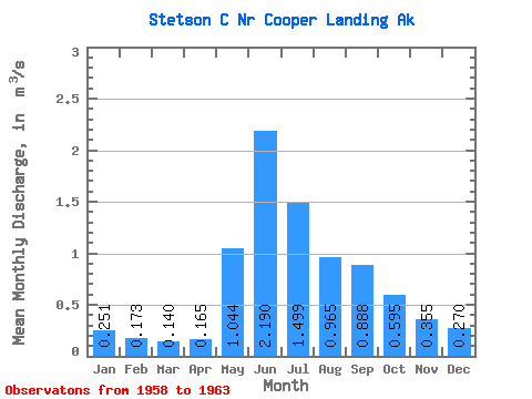
| Statistic | Jan | Feb | Mar | Apr | May | Jun | Jul | Aug | Sep | Oct | Nov | Dec | Annual |
|---|---|---|---|---|---|---|---|---|---|---|---|---|---|
| Mean | 0.25 | 0.17 | 0.14 | 0.17 | 1.04 | 2.19 | 1.50 | 0.96 | 0.89 | 0.59 | 0.35 | 0.27 | 0.74 |
| Standard Deviation | 0.15 | 0.05 | 0.01 | 0.02 | 0.35 | 0.49 | 0.26 | 0.28 | 0.46 | 0.21 | 0.07 | 0.09 | 0.17 |
| Min | 0.17 | 0.14 | 0.12 | 0.14 | 0.54 | 1.45 | 1.23 | 0.61 | 0.43 | 0.43 | 0.28 | 0.21 | 0.58 |
| Max | 0.52 | 0.27 | 0.16 | 0.19 | 1.41 | 2.79 | 1.98 | 1.32 | 1.71 | 0.95 | 0.47 | 0.44 | 0.97 |
| Coefficient of Variation | 0.61 | 0.31 | 0.11 | 0.14 | 0.33 | 0.23 | 0.18 | 0.28 | 0.52 | 0.35 | 0.20 | 0.35 | 0.23 |
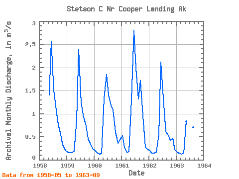
| Year | Jan | Feb | Mar | Apr | May | Jun | Jul | Aug | Sep | Oct | Nov | Dec | Annual | 1958 | 1.41 | 2.57 | 1.50 | 1.07 | 0.77 | 0.54 | 0.32 | 0.21 | 1959 | 0.17 | 0.15 | 0.15 | 0.19 | 0.87 | 2.38 | 1.23 | 0.92 | 0.78 | 0.46 | 0.36 | 0.25 | 0.66 | 1960 | 0.20 | 0.16 | 0.12 | 0.14 | 1.32 | 1.85 | 1.40 | 1.18 | 1.09 | 0.59 | 0.35 | 0.44 | 0.74 | 1961 | 0.52 | 0.27 | 0.16 | 0.18 | 1.29 | 2.79 | 1.98 | 1.32 | 1.71 | 0.95 | 0.28 | 0.23 | 0.97 | 1962 | 0.20 | 0.14 | 0.14 | 0.17 | 0.54 | 2.11 | 1.33 | 0.61 | 0.55 | 0.43 | 0.47 | 0.22 | 0.58 | 1963 | 0.17 | 0.14 | 0.13 | 0.15 | 0.83 | 1.45 | 1.55 | 0.70 | 0.43 |
|---|
 Return to R-Arctic Net Home Page