|
|
|||||||||||||||||
| Point ID: 9476 | Downloads | Plots | Site Data | Code: 15260500 |
|
|
|||||||||||||||||
| Download | |
|---|---|
| Site Descriptor Information | Site Time Series Data |
| Link to all available data | |
|
|
| View: | Statistics | Time Series |
| Units: | m3/s |
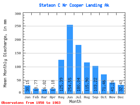
| Statistic | Jan | Feb | Mar | Apr | May | Jun | Jul | Aug | Sep | Oct | Nov | Dec | Annual |
|---|---|---|---|---|---|---|---|---|---|---|---|---|---|
| Mean | 30.16 | 18.91 | 16.76 | 19.15 | 125.36 | 254.53 | 179.97 | 115.86 | 103.24 | 71.45 | 41.27 | 32.44 | 1041.79 |
| Standard Deviation | 18.35 | 5.81 | 1.80 | 2.74 | 41.65 | 57.18 | 31.76 | 33.04 | 53.71 | 25.28 | 8.11 | 11.30 | 241.99 |
| Min | 19.98 | 15.54 | 14.69 | 15.79 | 64.61 | 168.18 | 147.35 | 72.84 | 50.03 | 51.43 | 32.15 | 25.78 | 814.78 |
| Max | 62.82 | 29.20 | 18.68 | 22.39 | 168.76 | 323.88 | 238.38 | 158.07 | 199.12 | 114.41 | 54.09 | 52.49 | 1376.98 |
| Coefficient of Variation | 0.61 | 0.31 | 0.11 | 0.14 | 0.33 | 0.23 | 0.18 | 0.28 | 0.52 | 0.35 | 0.20 | 0.35 | 0.23 |
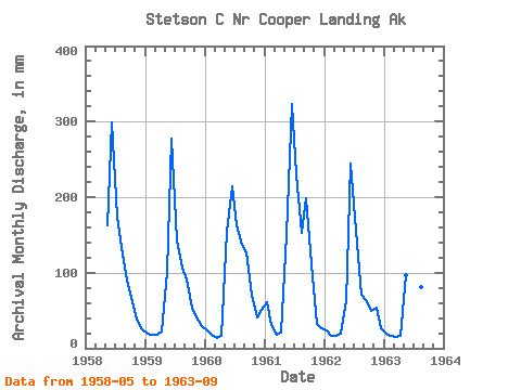
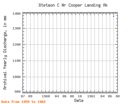
| Year | Jan | Feb | Mar | Apr | May | Jun | Jul | Aug | Sep | Oct | Nov | Dec | Annual | 1958 | 168.76 | 298.20 | 179.53 | 128.34 | 88.88 | 65.05 | 37.39 | 25.78 | 1959 | 20.41 | 16.96 | 18.25 | 22.39 | 104.76 | 277.03 | 147.35 | 110.03 | 90.96 | 55.06 | 41.47 | 29.65 | 933.22 | 1960 | 23.81 | 17.33 | 14.69 | 15.79 | 159.17 | 214.81 | 168.00 | 141.41 | 126.17 | 71.31 | 41.25 | 52.49 | 1042.17 | 1961 | 62.82 | 29.20 | 18.68 | 21.08 | 155.01 | 323.88 | 238.38 | 158.07 | 199.12 | 114.41 | 32.15 | 27.37 | 1376.98 | 1962 | 23.78 | 15.54 | 17.05 | 19.43 | 64.61 | 245.09 | 160.32 | 72.84 | 64.29 | 51.43 | 54.09 | 26.91 | 814.78 | 1963 | 19.98 | 15.54 | 15.14 | 17.05 | 99.83 | 168.18 | 186.26 | 84.48 | 50.03 |
|---|
 Return to R-Arctic Net Home Page