|
|
|||||||||||||||||
| Point ID: 9473 | Downloads | Plots | Site Data | Code: 15253000 |
|
|
|||||||||||||||||
| Download | |
|---|---|
| Site Descriptor Information | Site Time Series Data |
| Link to all available data | |
|
|
| View: | Statistics | Time Series |
| Units: | mm |
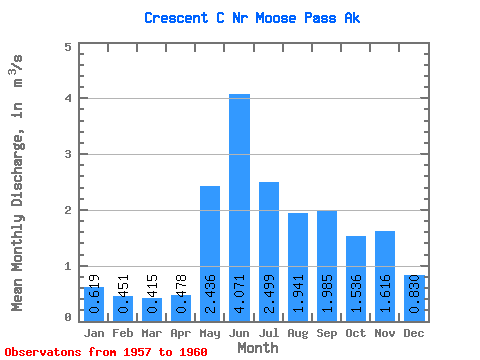
| Statistic | Jan | Feb | Mar | Apr | May | Jun | Jul | Aug | Sep | Oct | Nov | Dec | Annual |
|---|---|---|---|---|---|---|---|---|---|---|---|---|---|
| Mean | 0.62 | 0.45 | 0.41 | 0.48 | 2.44 | 4.07 | 2.50 | 1.94 | 1.98 | 1.54 | 1.62 | 0.83 | 1.46 |
| Standard Deviation | 0.26 | 0.06 | 0.02 | 0.04 | 0.81 | 0.37 | 0.60 | 0.66 | 0.56 | 0.37 | 0.87 | 0.23 | 0.07 |
| Min | 0.43 | 0.40 | 0.40 | 0.43 | 1.71 | 3.68 | 1.68 | 1.11 | 1.31 | 1.12 | 1.05 | 0.63 | 1.41 |
| Max | 0.91 | 0.51 | 0.43 | 0.51 | 3.41 | 4.53 | 3.13 | 2.70 | 2.64 | 1.83 | 2.62 | 1.09 | 1.51 |
| Coefficient of Variation | 0.42 | 0.13 | 0.04 | 0.09 | 0.33 | 0.09 | 0.24 | 0.34 | 0.28 | 0.24 | 0.54 | 0.28 | 0.05 |
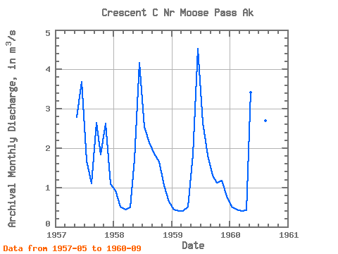
| Year | Jan | Feb | Mar | Apr | May | Jun | Jul | Aug | Sep | Oct | Nov | Dec | Annual | 1957 | 2.79 | 3.68 | 1.68 | 1.11 | 2.64 | 1.83 | 2.62 | 1.09 | 1958 | 0.91 | 0.51 | 0.43 | 0.49 | 1.71 | 4.17 | 2.54 | 2.14 | 1.85 | 1.65 | 1.05 | 0.63 | 1.51 | 1959 | 0.43 | 0.40 | 0.41 | 0.51 | 1.84 | 4.53 | 2.65 | 1.82 | 1.31 | 1.12 | 1.17 | 0.77 | 1.41 | 1960 | 0.51 | 0.44 | 0.40 | 0.43 | 3.41 | 3.90 | 3.13 | 2.70 | 2.14 |
|---|
 Return to R-Arctic Net Home Page