|
|
|||||||||||||||||
| Point ID: 9473 | Downloads | Plots | Site Data | Code: 15253000 |
|
|
|||||||||||||||||
| Download | |
|---|---|
| Site Descriptor Information | Site Time Series Data |
| Link to all available data | |
|
|
| View: | Statistics | Time Series |
| Units: | m3/s |
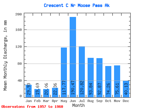
| Statistic | Jan | Feb | Mar | Apr | May | Jun | Jul | Aug | Sep | Oct | Nov | Dec | Annual |
|---|---|---|---|---|---|---|---|---|---|---|---|---|---|
| Mean | 29.94 | 19.85 | 20.04 | 22.34 | 117.78 | 190.45 | 120.79 | 93.82 | 92.87 | 74.24 | 75.59 | 40.14 | 832.45 |
| Standard Deviation | 12.48 | 2.58 | 0.82 | 2.03 | 39.13 | 17.19 | 29.18 | 32.04 | 26.03 | 17.87 | 40.72 | 11.23 | 38.36 |
| Min | 21.02 | 17.44 | 19.41 | 20.08 | 82.48 | 172.24 | 81.06 | 53.56 | 61.17 | 54.22 | 49.37 | 30.55 | 805.33 |
| Max | 44.20 | 22.58 | 20.97 | 23.99 | 164.79 | 212.02 | 151.11 | 130.30 | 123.43 | 88.58 | 122.50 | 52.50 | 859.57 |
| Coefficient of Variation | 0.42 | 0.13 | 0.04 | 0.09 | 0.33 | 0.09 | 0.24 | 0.34 | 0.28 | 0.24 | 0.54 | 0.28 | 0.05 |
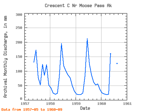
| Year | Jan | Feb | Mar | Apr | May | Jun | Jul | Aug | Sep | Oct | Nov | Dec | Annual | 1957 | 135.04 | 172.24 | 81.06 | 53.56 | 123.43 | 88.58 | 122.50 | 52.50 | 1958 | 44.20 | 22.58 | 20.97 | 22.95 | 82.48 | 195.24 | 122.93 | 103.45 | 86.65 | 79.92 | 49.37 | 30.55 | 859.57 | 1959 | 21.02 | 17.44 | 19.73 | 23.99 | 88.80 | 212.02 | 128.05 | 87.95 | 61.17 | 54.22 | 54.89 | 37.36 | 805.33 | 1960 | 24.58 | 19.53 | 19.41 | 20.08 | 164.79 | 182.30 | 151.11 | 130.30 | 100.25 |
|---|
 Return to R-Arctic Net Home Page