|
|
|||||||||||||||||
| Point ID: 9441 | Downloads | Plots | Site Data | Code: 15266110 |
|
|
|||||||||||||||||
| Download | |
|---|---|
| Site Descriptor Information | Site Time Series Data |
| Link to all available data | |
|
|
| View: | Statistics | Time Series |
| Units: | mm |
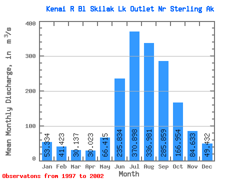
| Statistic | Jan | Feb | Mar | Apr | May | Jun | Jul | Aug | Sep | Oct | Nov | Dec | Annual |
|---|---|---|---|---|---|---|---|---|---|---|---|---|---|
| Mean | 53.33 | 41.42 | 30.14 | 30.02 | 66.42 | 235.83 | 370.90 | 336.98 | 285.86 | 166.95 | 84.63 | 49.43 | 144.94 |
| Standard Deviation | 21.99 | 15.71 | 4.99 | 3.80 | 15.01 | 41.30 | 37.87 | 32.41 | 83.73 | 36.61 | 25.67 | 9.04 | 18.35 |
| Min | 32.95 | 25.24 | 24.64 | 25.16 | 41.34 | 174.31 | 338.66 | 291.92 | 160.25 | 111.49 | 59.63 | 39.27 | 125.45 |
| Max | 83.83 | 65.54 | 37.53 | 35.13 | 85.97 | 277.37 | 436.17 | 385.20 | 392.47 | 212.33 | 125.75 | 59.92 | 169.51 |
| Coefficient of Variation | 0.41 | 0.38 | 0.17 | 0.13 | 0.23 | 0.17 | 0.10 | 0.10 | 0.29 | 0.22 | 0.30 | 0.18 | 0.13 |
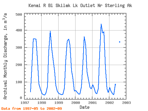
| Year | Jan | Feb | Mar | Apr | May | Jun | Jul | Aug | Sep | Oct | Nov | Dec | Annual | 1997 | 41.34 | 174.31 | 350.76 | 349.76 | 348.73 | 212.33 | 89.60 | 57.76 | 1998 | 34.05 | 25.24 | 24.64 | 35.13 | 74.67 | 277.37 | 394.79 | 291.92 | 232.37 | 163.19 | 80.15 | 43.28 | 139.73 | 1999 | 32.95 | 30.40 | 26.61 | 28.18 | 62.94 | 219.43 | 338.66 | 349.21 | 313.61 | 166.28 | 125.75 | 46.93 | 145.08 | 2000 | 48.59 | 40.09 | 30.35 | 29.55 | 70.98 | 210.04 | 362.91 | 313.21 | 160.25 | 111.49 | 68.04 | 59.92 | 125.45 | 2001 | 83.83 | 65.54 | 37.53 | 32.10 | 62.58 | 258.27 | 436.17 | 385.20 | 392.47 | 181.49 | 59.63 | 39.27 | 169.51 | 2002 | 67.26 | 45.84 | 31.56 | 25.16 | 85.97 | 275.58 | 342.09 | 332.59 | 267.72 |
|---|
 Return to R-Arctic Net Home Page