|
|
|||||||||||||||||
| Point ID: 9441 | Downloads | Plots | Site Data | Code: 15266110 |
|
|
|||||||||||||||||
| Download | |
|---|---|
| Site Descriptor Information | Site Time Series Data |
| Link to all available data | |
|
|
| View: | Statistics | Time Series |
| Units: | m3/s |
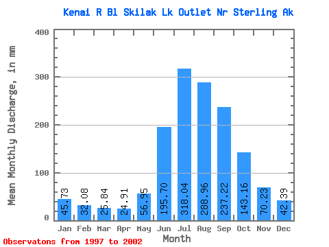
| Statistic | Jan | Feb | Mar | Apr | May | Jun | Jul | Aug | Sep | Oct | Nov | Dec | Annual |
|---|---|---|---|---|---|---|---|---|---|---|---|---|---|
| Mean | 45.73 | 32.36 | 25.84 | 24.91 | 56.94 | 195.70 | 318.00 | 288.92 | 237.22 | 143.14 | 70.23 | 42.38 | 1464.51 |
| Standard Deviation | 18.85 | 12.27 | 4.28 | 3.15 | 12.87 | 34.27 | 32.47 | 27.79 | 69.48 | 31.39 | 21.31 | 7.75 | 185.43 |
| Min | 28.25 | 19.71 | 21.12 | 20.88 | 35.45 | 144.65 | 290.36 | 250.28 | 132.99 | 95.58 | 49.48 | 33.67 | 1267.58 |
| Max | 71.87 | 51.20 | 32.18 | 29.15 | 73.71 | 230.18 | 373.96 | 330.26 | 325.69 | 182.05 | 104.36 | 51.38 | 1712.71 |
| Coefficient of Variation | 0.41 | 0.38 | 0.17 | 0.13 | 0.23 | 0.17 | 0.10 | 0.10 | 0.29 | 0.22 | 0.30 | 0.18 | 0.13 |
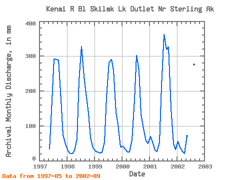
| Year | Jan | Feb | Mar | Apr | May | Jun | Jul | Aug | Sep | Oct | Nov | Dec | Annual | 1997 | 35.45 | 144.65 | 300.74 | 299.87 | 289.39 | 182.05 | 74.36 | 49.52 | 1998 | 29.19 | 19.71 | 21.12 | 29.15 | 64.02 | 230.18 | 338.48 | 250.28 | 192.83 | 139.91 | 66.51 | 37.11 | 1411.87 | 1999 | 28.25 | 23.75 | 22.81 | 23.38 | 53.96 | 182.09 | 290.36 | 299.40 | 260.25 | 142.56 | 104.36 | 40.24 | 1465.88 | 2000 | 41.66 | 31.32 | 26.02 | 24.52 | 60.86 | 174.30 | 311.15 | 268.54 | 132.99 | 95.58 | 56.46 | 51.38 | 1267.58 | 2001 | 71.87 | 51.20 | 32.18 | 26.64 | 53.65 | 214.32 | 373.96 | 330.26 | 325.69 | 155.61 | 49.48 | 33.67 | 1712.71 | 2002 | 57.66 | 35.81 | 27.06 | 20.88 | 73.71 | 228.69 | 293.30 | 285.15 | 222.16 |
|---|
 Return to R-Arctic Net Home Page