|
|
|||||||||||||||||
| Point ID: 9432 | Downloads | Plots | Site Data | Code: 15297482 |
|
|
|||||||||||||||||
| Download | |
|---|---|
| Site Descriptor Information | Site Time Series Data |
| Link to all available data | |
|
|
| View: | Statistics | Time Series |
| Units: | mm |
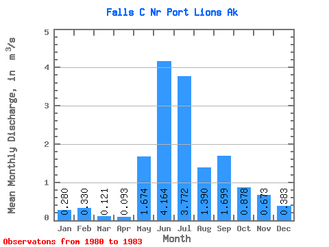
| Statistic | Jan | Feb | Mar | Apr | May | Jun | Jul | Aug | Sep | Oct | Nov | Dec | Annual |
|---|---|---|---|---|---|---|---|---|---|---|---|---|---|
| Mean | 0.28 | 0.33 | 0.12 | 0.09 | 1.67 | 4.16 | 3.77 | 1.39 | 1.70 | 0.88 | 0.67 | 0.38 | 1.28 |
| Standard Deviation | 0.07 | 0.29 | 0.05 | 0.02 | 1.13 | 0.26 | 0.36 | 0.54 | 0.96 | 0.74 | 0.66 | 0.19 | 0.21 |
| Min | 0.23 | 0.11 | 0.07 | 0.07 | 0.40 | 4.00 | 3.37 | 0.78 | 0.71 | 0.27 | 0.28 | 0.17 | 1.13 |
| Max | 0.36 | 0.66 | 0.16 | 0.11 | 2.55 | 4.47 | 4.06 | 1.80 | 2.63 | 1.69 | 1.43 | 0.50 | 1.42 |
| Coefficient of Variation | 0.24 | 0.89 | 0.39 | 0.23 | 0.68 | 0.06 | 0.10 | 0.39 | 0.56 | 0.84 | 0.98 | 0.48 | 0.16 |
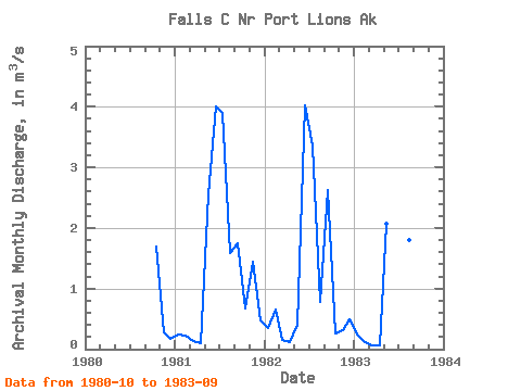
| Year | Jan | Feb | Mar | Apr | May | Jun | Jul | Aug | Sep | Oct | Nov | Dec | Annual | 1980 | 1.69 | 0.28 | 0.17 | 1981 | 0.23 | 0.22 | 0.14 | 0.09 | 2.55 | 4.00 | 3.89 | 1.59 | 1.76 | 0.67 | 1.43 | 0.48 | 1.42 | 1982 | 0.36 | 0.66 | 0.16 | 0.11 | 0.40 | 4.02 | 3.37 | 0.78 | 2.63 | 0.27 | 0.31 | 0.50 | 1.13 | 1983 | 0.25 | 0.11 | 0.07 | 0.07 | 2.07 | 4.47 | 4.06 | 1.80 | 0.71 |
|---|
 Return to R-Arctic Net Home Page