|
|
|||||||||||||||||
| Point ID: 9432 | Downloads | Plots | Site Data | Code: 15297482 |
|
|
|||||||||||||||||
| Download | |
|---|---|
| Site Descriptor Information | Site Time Series Data |
| Link to all available data | |
|
|
| View: | Statistics | Time Series |
| Units: | m3/s |
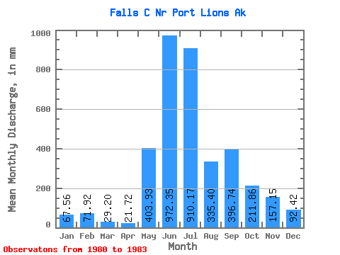
| Statistic | Jan | Feb | Mar | Apr | May | Jun | Jul | Aug | Sep | Oct | Nov | Dec | Annual |
|---|---|---|---|---|---|---|---|---|---|---|---|---|---|
| Mean | 67.45 | 72.64 | 29.09 | 21.72 | 403.92 | 972.32 | 909.96 | 335.42 | 396.67 | 211.93 | 157.10 | 92.45 | 3627.66 |
| Standard Deviation | 16.13 | 64.38 | 11.44 | 4.89 | 272.78 | 61.64 | 87.18 | 130.35 | 223.92 | 177.68 | 153.97 | 44.80 | 587.25 |
| Min | 56.41 | 23.85 | 16.23 | 16.68 | 96.19 | 934.12 | 812.09 | 187.77 | 166.40 | 64.07 | 64.39 | 40.80 | 3212.42 |
| Max | 85.96 | 145.61 | 38.14 | 26.44 | 615.98 | 1043.43 | 979.28 | 434.59 | 613.64 | 409.04 | 334.83 | 120.65 | 4042.91 |
| Coefficient of Variation | 0.24 | 0.89 | 0.39 | 0.23 | 0.68 | 0.06 | 0.10 | 0.39 | 0.56 | 0.84 | 0.98 | 0.48 | 0.16 |
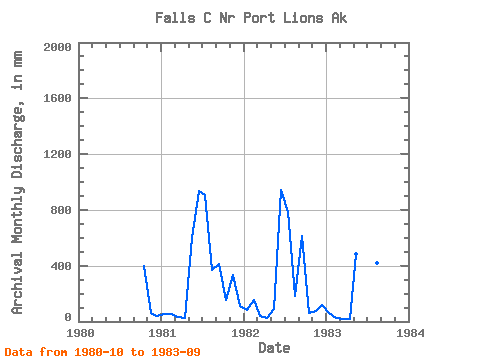
| Year | Jan | Feb | Mar | Apr | May | Jun | Jul | Aug | Sep | Oct | Nov | Dec | Annual | 1980 | 409.04 | 64.39 | 40.80 | 1981 | 56.41 | 48.45 | 32.88 | 22.03 | 615.98 | 934.12 | 938.51 | 383.89 | 409.95 | 162.67 | 334.83 | 115.91 | 4042.91 | 1982 | 85.96 | 145.61 | 38.14 | 26.44 | 96.19 | 939.40 | 812.09 | 187.77 | 613.64 | 64.07 | 72.08 | 120.65 | 3212.42 | 1983 | 59.99 | 23.85 | 16.23 | 16.68 | 499.58 | 1043.43 | 979.28 | 434.59 | 166.40 |
|---|
 Return to R-Arctic Net Home Page