|
|
|||||||||||||||||
| Point ID: 9431 | Downloads | Plots | Site Data | Code: 15273102 |
|
|
|||||||||||||||||
| Download | |
|---|---|
| Site Descriptor Information | Site Time Series Data |
| Link to all available data | |
|
|
| View: | Statistics | Time Series |
| Units: | mm |
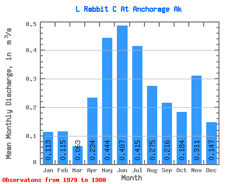
| Statistic | Jan | Feb | Mar | Apr | May | Jun | Jul | Aug | Sep | Oct | Nov | Dec | Annual |
|---|---|---|---|---|---|---|---|---|---|---|---|---|---|
| Mean | 0.11 | 0.12 | 0.06 | 0.23 | 0.44 | 0.49 | 0.41 | 0.28 | 0.22 | 0.18 | 0.31 | 0.15 | |
| Standard Deviation | 0.10 | 0.07 | 0.07 | 0.16 | 0.13 | ||||||||
| Min | 0.11 | 0.12 | 0.06 | 0.23 | 0.38 | 0.44 | 0.37 | 0.16 | 0.12 | 0.18 | 0.31 | 0.15 | |
| Max | 0.11 | 0.12 | 0.06 | 0.23 | 0.51 | 0.54 | 0.46 | 0.39 | 0.31 | 0.18 | 0.31 | 0.15 | |
| Coefficient of Variation | 0.22 | 0.15 | 0.17 | 0.59 | 0.61 |
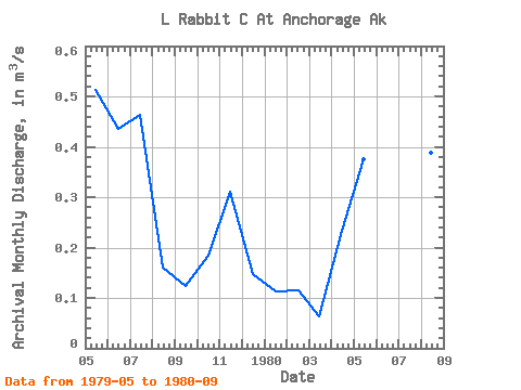
| Year | Jan | Feb | Mar | Apr | May | Jun | Jul | Aug | Sep | Oct | Nov | Dec | Annual | 1979 | 0.51 | 0.44 | 0.46 | 0.16 | 0.12 | 0.18 | 0.31 | 0.15 | 1980 | 0.11 | 0.12 | 0.06 | 0.23 | 0.38 | 0.54 | 0.37 | 0.39 | 0.31 |
|---|
 Return to R-Arctic Net Home Page