|
|
|||||||||||||||||
| Point ID: 9431 | Downloads | Plots | Site Data | Code: 15273102 |
|
|
|||||||||||||||||
| Download | |
|---|---|
| Site Descriptor Information | Site Time Series Data |
| Link to all available data | |
|
|
| View: | Statistics | Time Series |
| Units: | m3/s |
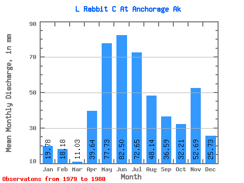
| Statistic | Jan | Feb | Mar | Apr | May | Jun | Jul | Aug | Sep | Oct | Nov | Dec | Annual |
|---|---|---|---|---|---|---|---|---|---|---|---|---|---|
| Mean | 19.78 | 18.29 | 11.00 | 39.69 | 77.77 | 82.58 | 72.55 | 48.09 | 36.51 | 32.24 | 52.76 | 25.81 | |
| Standard Deviation | 17.09 | 12.33 | 12.01 | 28.29 | 22.19 | ||||||||
| Min | 19.78 | 18.29 | 11.00 | 39.69 | 65.68 | 73.86 | 64.06 | 28.09 | 20.82 | 32.24 | 52.76 | 25.81 | |
| Max | 19.78 | 18.29 | 11.00 | 39.69 | 89.85 | 91.30 | 81.04 | 68.09 | 52.20 | 32.24 | 52.76 | 25.81 | |
| Coefficient of Variation | 0.22 | 0.15 | 0.17 | 0.59 | 0.61 |
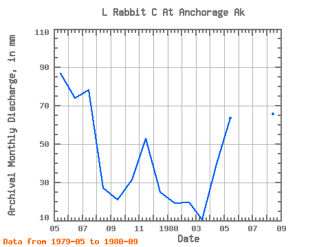
| Year | Jan | Feb | Mar | Apr | May | Jun | Jul | Aug | Sep | Oct | Nov | Dec | Annual | 1979 | 89.85 | 73.86 | 81.04 | 28.09 | 20.82 | 32.24 | 52.76 | 25.81 | 1980 | 19.78 | 18.29 | 11.00 | 39.69 | 65.68 | 91.30 | 64.06 | 68.09 | 52.20 |
|---|
 Return to R-Arctic Net Home Page