|
|
|||||||||||||||||
| Point ID: 9414 | Downloads | Plots | Site Data | Code: 15485200 |
|
|
|||||||||||||||||
| Download | |
|---|---|
| Site Descriptor Information | Site Time Series Data |
| Link to all available data | |
|

|
| View: | Statistics | Time Series |
| Units: | mm |
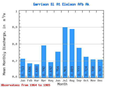
| Statistic | Jan | Feb | Mar | Apr | May | Jun | Jul | Aug | Sep | Oct | Nov | Dec | Annual |
|---|---|---|---|---|---|---|---|---|---|---|---|---|---|
| Mean | 0.71 | 0.69 | 0.68 | 0.79 | 0.69 | 0.75 | 0.90 | 0.89 | 0.78 | 0.72 | 0.71 | 0.71 | |
| Standard Deviation | 0.15 | ||||||||||||
| Min | 0.71 | 0.69 | 0.68 | 0.79 | 0.69 | 0.75 | 0.79 | 0.89 | 0.78 | 0.72 | 0.71 | 0.71 | |
| Max | 0.71 | 0.69 | 0.68 | 0.79 | 0.69 | 0.75 | 1.01 | 0.89 | 0.78 | 0.72 | 0.71 | 0.71 | |
| Coefficient of Variation | 0.17 |
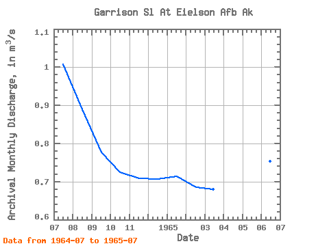
| Year | Jan | Feb | Mar | Apr | May | Jun | Jul | Aug | Sep | Oct | Nov | Dec | Annual | 1964 | 1.01 | 0.89 | 0.78 | 0.72 | 0.71 | 0.71 | 1965 | 0.71 | 0.69 | 0.68 | 0.79 | 0.69 | 0.75 | 0.79 |
|---|
 Return to R-Arctic Net Home Page