|
|
|||||||||||||||||
| Point ID: 9414 | Downloads | Plots | Site Data | Code: 15485200 |
|
|
|||||||||||||||||
| Download | |
|---|---|
| Site Descriptor Information | Site Time Series Data |
| Link to all available data | |
|
|
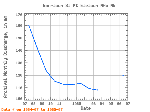
| View: | Statistics | Time Series |
| Units: | m3/s |
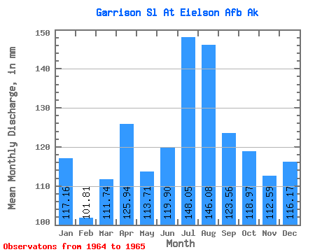
| Statistic | Jan | Feb | Mar | Apr | May | Jun | Jul | Aug | Sep | Oct | Nov | Dec | Annual |
|---|---|---|---|---|---|---|---|---|---|---|---|---|---|
| Mean | 117.06 | 102.69 | 111.66 | 125.94 | 113.76 | 119.95 | 148.03 | 146.01 | 123.55 | 119.01 | 112.58 | 116.17 | |
| Standard Deviation | 24.86 | ||||||||||||
| Min | 117.06 | 102.69 | 111.66 | 125.94 | 113.76 | 119.95 | 130.45 | 146.01 | 123.55 | 119.01 | 112.58 | 116.17 | |
| Max | 117.06 | 102.69 | 111.66 | 125.94 | 113.76 | 119.95 | 165.61 | 146.01 | 123.55 | 119.01 | 112.58 | 116.17 | |
| Coefficient of Variation | 0.17 |
| Year | Jan | Feb | Mar | Apr | May | Jun | Jul | Aug | Sep | Oct | Nov | Dec | Annual | 1964 | 165.61 | 146.01 | 123.55 | 119.01 | 112.58 | 116.17 | 1965 | 117.06 | 102.69 | 111.66 | 125.94 | 113.76 | 119.95 | 130.45 |
|---|
 Return to R-Arctic Net Home Page